
Page 111 - Standard Handbook Petroleum Natural Gas Engineering VOLUME2
P. 111
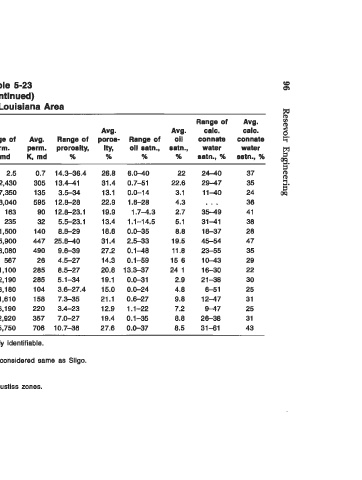
Table  5-23                                       CB
                                                   Q1
 (contlnued)
 (c)  North Louisiana Area                         w
 Range of   Avg.                    Range of   Avg.   8
 Avg.   prod.   prod.   Avg.   Avg.   calc.   calc.   2
 Range ol   prod.   thlck-   thlck-   Range of   Avg.   Range of   poroa-  Range of   oil   connate   connate  8.
 Fluid   pmd.   depth,   ness,   ness,   perm.   perm.   proroslty,   Ity,   011  oatn.,   oatn.,   water   water
 Formatlon   prod.   depth, tt   R   tt   tt   K,  md   K,  md   %   %   %   %   satn.,  %   satn.,  %
                                                   2.
                                                   0
 Annona Chalk   0   1,362-  1,594   1,480   15-69   42   0.1-   2.5   0.7   14.3-36.4   26.6   6.0-40   22   24-40   37   2.
 Buckrange   C/O   1,908-  2,877   2,393   2-24   13   0.1-2,430   305   13.4-41   31.4   0.7-51   22.6   2947   35
 Cotton Vallep  GICIO  3,650-  9,450   7,450   4-37   20   0.1-7,350   135   3.5-34   13.1   0.0-14   3.1   1140   24   09
 Eaglefordb   C   8,376-  6,417   6,397   9-11   10   3.5-3,040   595  12.8-26   22.9   1.6-28   4.3   . , .   36
 Fredericksburg  G/C   6,610-  9,860   6,220   6- 6   7   1.6-   163   90  12.8-23.1   19.9   1.74.3   2.7   3549   41
 Haynesville   C  10,380-10,530   10,420   22-59   40   0.1-  235   32   5.5-23.1   13.4   1.1-14.5   5.1   31-41   38
 Hosston   C/O  5,420-  7,565   6,460   5-15   12   0.4-1,500   140   8.8-29   18.6   0.0-35   6.6   16-37   26
 Nacatoch   0   1,223-  2,176   1,700   6-12   6   274,900   447  25.840   31.4   2.5-33   19.5   45-54   47
 Paluxy   C/O   2,195-  3,240   2,717   2-28   16   0.25,060   490   9.6-39   27.2   0.1-48   11.6   23-55   35
 PettiP   C/O   3,995-  7,070   5,690   3-30   14   0.1-  567   26   4.5-27   14.3   0.169   15 6   10-43   29
 Plne Islandd   0   4,960-  5,060   5,010   5-13   9   0.2-1,100   285   8.5-27   20.6  13.3-37   24  1   16-30   22
 Rodessa-   GlClO  3,625-  5,650   4,860   6-52   18   0.1-2,190   265   5.1-34   19.1   0.0-31   2.9   21-36   30
 Schulef   GICIO  5,500-  9,190   6,450   4-51   19   0 13,160   104   3.6-27.4   15.0   0.0-24   4.6   6-51   25
 Sligog   C/O  2,685-  5,400   4,500   3-21   7   0.1-1,610   158   7.3-35   21.1   0.6-27   9.8   1247   31
 Smackover   C/O  9,980-10,790   10,360   6-55   24   0.1-6,190   220   3.4-23   12.9   1.1-22   7.2   9-47   25
 Travis Peakh   C/O   5,890-  7,900   6,895   7-35   18   0.1-2,920   357   7.0-27   19.4   0.1-35   6.6   26-36   31
 Tuscaloosa   G/C/O  2,645-  9,680   5,164   4-44   24   0.1-5,750   706  10.7-36   27.6   0.0-37   6.5   31-61   43
 a  Data reported where member formations of  Cotton Valley  group not readily identifiable.
 Data reported as  Eutaw in some areas.
 Includes data reported as  Pettit, Upper Pettit, and Mid Pettit.  Sometimes considered same as Sligo.
 Sometimes referred to as Woodruff.
 a  Includes data reported locally for  Jeter,  HIII,  Kilpatrlck, and Fowler zones.
 I Includes data reported locally for  Bodcaw,  Vaughn,  Doris,  McFerrin,  and Justiss zones.
 Includes data reported as Birdsong-Owens.
 Frequently considered same as  Hosston.