
Page 39 - Urban water supply handbook
P. 39
URBAN WATER INFRASTRUCTURE: A HISTORICAL PERSPECTIVE
1.38 HISTORY, PLANNING, OUTSOURCING
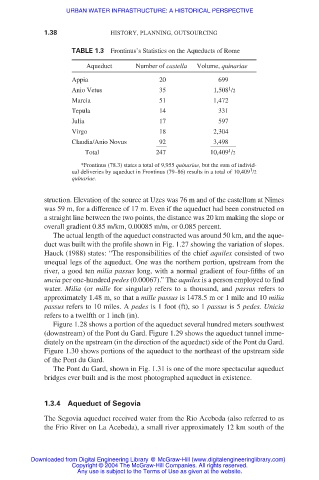
TABLE 1.3 Frontinus’s Statistics on the Aqueducts of Rome
Aqueduct Number of castella Volume, quinariae
Appia 20 699
1
Anio Vetus 35 1,508 /2
Marcia 51 1,472
Tepula 14 331
Julia 17 597
Virgo 18 2,304
Claudia/Anio Novus 92 3,498
1
Total 247 10,409 /2
*Frontinus (78.3) states a total of 9,955 quinariae, but the sum of individ-
1
ual deliveries by aqueduct in Frontinus (79–86) results in a total of 10,409 /2
quinariae.
struction. Elevation of the source at Uzes was 76 m and of the castellum at Nîmes
was 59 m, for a difference of 17 m. Even if the aqueduct had been constructed on
a straight line between the two points, the distance was 20 km making the slope or
overall gradient 0.85 m/km, 0.00085 m/m, or 0.085 percent.
The actual length of the aqueduct constructed was around 50 km, and the aque-
duct was built with the profile shown in Fig. 1.27 showing the variation of slopes.
Hauck (1988) states: “The responsibilities of the chief aquilex consisted of two
unequal legs of the aqueduct. One was the northern portion, upstream from the
river, a good ten milia passus long, with a normal gradient of four-fifths of an
uncia per one-hundred pedes (0.00067).” The aquilex is a person employed to find
water. Milia (or mille for singular) refers to a thousand, and passus refers to
approximately 1.48 m, so that a mille passus is 1478.5 m or 1 mile and 10 milia
passus refers to 10 miles. A pedes is 1 foot (ft), so 1 passus is 5 pedes. Unicia
refers to a twelfth or 1 inch (in).
Figure 1.28 shows a portion of the aqueduct several hundred meters southwest
(downstream) of the Pont du Gard. Figure 1.29 shows the aqueduct tunnel imme-
diately on the upstream (in the direction of the aqueduct) side of the Pont du Gard.
Figure 1.30 shows portions of the aqueduct to the northeast of the upstream side
of the Pont du Gard.
The Pont du Gard, shown in Fig. 1.31 is one of the more spectacular aqueduct
bridges ever built and is the most photographed aqueduct in existence.
1.3.4 Aqueduct of Segovia
The Segovia aqueduct received water from the Rio Acebeda (also referred to as
the Frio River on La Acebeda), a small river approximately 12 km south of the
Downloaded from Digital Engineering Library @ McGraw-Hill (www.digitalengineeringlibrary.com)
Copyright © 2004 The McGraw-Hill Companies. All rights reserved.
Any use is subject to the Terms of Use as given at the website.