
Page 41 - Urban water supply handbook
P. 41
URBAN WATER INFRASTRUCTURE: A HISTORICAL PERSPECTIVE
1.40 HISTORY, PLANNING, OUTSOURCING
Source
76 m.
UZES
GARRIGUES D'UZES
100
100 aqueduct
Vers
R.Alz on
Collias Pont du Gard
S t. Nicholas 24 m. 65.3 m.
37 m.
18 m.
100
Remoulins
R. Gardon
St.Bonnet
200
G A R R I G U E S D E N I M E Sernhac
Bezouce Meynes R.Gardo n
aqueduct
St. Gervasy
100 N
Marguerittes
NIMES
0 5 10 km.
59 m.
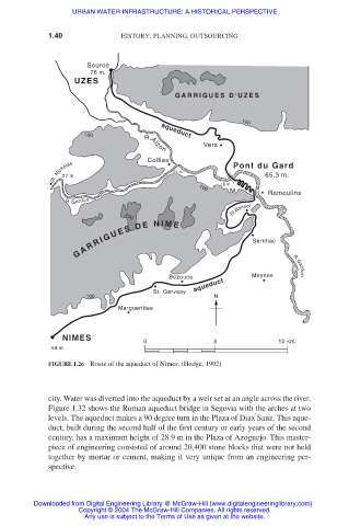
FIGURE 1.26 Route of the aqueduct of Nîmes. (Hodge, 1992)
city. Water was diverted into the aqueduct by a weir set at an angle across the river.
Figure 1.32 shows the Roman aqueduct bridge in Segovia with the arches at two
levels. The aqueduct makes a 90 degree turn in the Plaza of Diax Sanz. This aque-
duct, built during the second half of the first century or early years of the second
century, has a maximum height of 28.9 m in the Plaza of Azoguejo. This master-
piece of engineering consisted of around 20,400 stone blocks that were not held
together by mortar or cement, making it very unique from an engineering per-
spective.
Downloaded from Digital Engineering Library @ McGraw-Hill (www.digitalengineeringlibrary.com)
Copyright © 2004 The McGraw-Hill Companies. All rights reserved.
Any use is subject to the Terms of Use as given at the website.