
Page 48 - Urban water supply handbook
P. 48
URBAN WATER INFRASTRUCTURE: A HISTORICAL PERSPECTIVE
URBAN WATER INFRASTRUCTURE 1.47
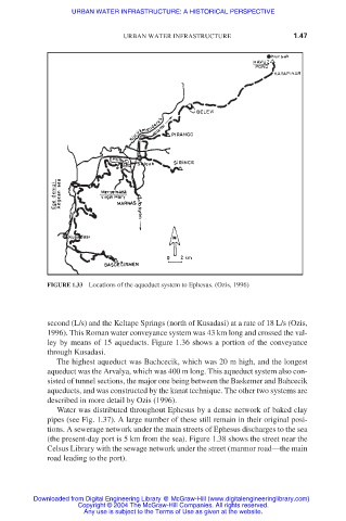
FIGURE 1.33 Locations of the aqueduct system to Ephesus. (Ozis, 1996)
second (L/s) and the Keltape Springs (north of Kusadasi) at a rate of 18 L/s (Ozis,
1996). This Roman water conveyance system was 43 km long and crossed the val-
ley by means of 15 aqueducts. Figure 1.36 shows a portion of the conveyance
through Kusadasi.
The highest aqueduct was Bachcecik, which was 20 m high, and the longest
aqueduct was the Arvalya, which was 400 m long. This aqueduct system also con-
sisted of tunnel sections, the major one being between the Baskemer and Bahcecik
aqueducts, and was constructed by the kanat technique. The other two systems are
described in more detail by Ozis (1996).
Water was distributed throughout Ephesus by a dense network of baked clay
pipes (see Fig. 1.37). A large number of these still remain in their original posi-
tions. A sewerage network under the main streets of Ephesus discharges to the sea
(the present-day port is 5 km from the sea). Figure 1.38 shows the street near the
Celsus Library with the sewage network under the street (marmor road—the main
road leading to the port).
Downloaded from Digital Engineering Library @ McGraw-Hill (www.digitalengineeringlibrary.com)
Copyright © 2004 The McGraw-Hill Companies. All rights reserved.
Any use is subject to the Terms of Use as given at the website.