
Page 390 - Materials Chemistry, Second Edition
P. 390
CAT3525_C10.qxd 1/31/2005 12:00 PM Page 361
The Sanitary Landfill 361
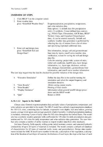
OVERVIEW OF STEPS
1. Click HELP 3 on the computer screen
2. Enter weather data
press “Enter/Edit Weather Data”: Evapotranspiration, precipitation, temperature,
and solar radiation data.
Data options: 1) default data (for precipitation
only); 2) synthetic; 3) user-defined data sources,
e.g., NOAA Tape, Climatedata, ASCII data, HELP
Version 2 data, and Canadian Climatological
data.; 4) can be entered manually. Default and
synthetic weather data generation is performed by
selecting the city of interest from a list of cities
and specifying (optional) additional data.
3. Enter soil and design data
press “Enter/Edit Soil and Site information, design, soil and geomembrane
Design Data”: liner data by layers, runoff curve number, data
verification, screen for saving the soil and design
data file.
Cells for entering: project title, system of units,
initial soil conditions, landfill area, layer design
information, i.e., layer type, thickness, soil tex-
ture, drainage characteristics, geomembrane liner
information, and runoff curve number information
The user may request that the data be checked for possible violation of the design rules.
4. “Executive Simulation” Define the data files to be used in running the
simulation and select the output frequency and
simulation duration.
5. “View Results” Allows seeing output results.
6. “Print Results” Printing of final results
7. “Display Guidance” Information about general landfill design proce-
dures and the HELP model
8. “Quit” Return to DOS
A.10.1.3.2 Inputs to the Model
Climate data: General evapotranspiration data and daily values of precipitation, temperature, and
solar radiation are provided in the model. The HELP model has a default evapotranspiration database
for 183 U.S. cities, containing data for latitude, evaporative zone depths, leaf area indices, growing
season, average wind speed, and average quarterly relative humidity. A default precipitation database
is included, containing 5 years of daily values for 102 cities throughout the United States. The model
also has a synthetic weather generator with coefficients for 139 cities for daily precipitation data gen-
eration and for 183 cities for daily temperature and solar radiation data generation. The user inter-
face also contains a number of utility routines to import weather data from other databases.
Soil data: Porosity, field capacity, wilting point, initial moisture content, and saturated hydraulic
conductivity of up to 20 layers of materials is included. The model contains a default soil database
of characteristics for 42 types of materials (soils, waste, and geosynthetics). Design data require-
ments include the AMC-II runoff curve number for the site, a description of the vegetation, a descrip-
tion of the function of each layer of material, the thickness of each layer, the slope at the base of each