
Page 105 - Water Engineering Hydraulics, Distribution and Treatment
P. 105
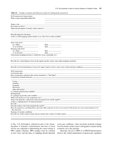
Example of sanitary and field survey report for hydrogeologic assessment
                                    Table 3.6
                                    Well location and characteristics
                                    Water system name/address/Fed ID#
                                    Name of site
                                    Description of device
                                    Name and description of nearby surface source(s)
                                    Describe datum for elevations
                                    Is there a USGS gauging station nearby, or are other flow records available?
                                    Static water level                              3.20 Groundwater Under the Direct Influence of Surface Water  83
                                      As a depth                         Date
                                      As an elevation                    Date
                                    Pumping water level
                                      As a depth                         Date
                                      As an elevation                    Date
                                    Characterize pumping practices or spring flow (rates, seasonally, etc.)
                                    Describe the vertical distance between the aquifer and the surface water under pumping conditions

                                    Describe the horizontal distance between the aquifer and the surface-water source under pumping conditions
                                    Well construction
                                    Construction date
                                    Does construction conform to the current standards (i.e., Ten State)?
                                    Construction methods/materials
                                      Casing
                                      Grouting
                                      Screening
                                      Well house
                                      Other information
                                    Is a detailed plan/drawing available?
                                    Hydrogeology
                                    Is a geologic log for this well available?
                                    What is the thickness of the unsaturated zone?
                                    What is the hydraulic conductivity of the unsaturated zone and the aquifer?
                                    Is there a confining layer? At what elevation(s)?
                                    Describe
                                    Does the surface-water body penetrate the aquifer?
                                    Draw the aquifer(s), confining unit(s), and water table using one or more cross-sections with at least one cross-section parallel to the
                                     flow direction
                                    Summary of sanitary conditions
                                    Describe the results of past sanitary surveys and give the location of written reports


                                    in Fig. 3.18. Information collected as part of the charac-  worst-case conditions, when maximum potential recharge
                                    terization of hydraulic communication and time of travel  from the nearby surface water is taking place (usually during
                                    will be very important in determining the correct timing of  extremely wet or dry periods).
                                    MPA sample collection. MPA samples must be collected  Basically, the use of MPA in a GWUDI determination
                                    at least twice, and the dates of sampling should represent  involves the careful enumeration of microscopic organisms