
Page 70 - Water Engineering Hydraulics, Distribution and Treatment
P. 70
48
Water Sources: Groundwater
Chapter 3
Sands and gravels are by far the best water-producing
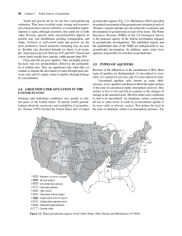
an updated assessment of the groundwater situation in each of
sediments. They have excellent water storage and transmis-
Thomas’s regions and has also described the occurrence and
sion characteristics and are ordinarily so situated that replen-
development of groundwater in each of the states. The Water
ishment is rapid, although extremely fine sands are of little
Resources Division (WRD) of the US Geological Survey
value. Porosity, specific yield, and permeability depend on
is the principal agency of the federal government engaged
particle size, size distribution, packing configuration, and
shape. Uniform or well-sorted sands and gravels are the
in groundwater investigations. The published reports and
the unpublished data of the WRD are indispensable to any
most productive; mixed materials containing clay are least
so. Boulder clay deposited beneath ice sheets is an exam-
groundwater investigation. In addition, many states have
ple. Typical porosities lie between 25% and 65%. Gravel and
agencies responsible for activities in groundwater.
coarse sands usually have specific yields greater than 20%.
Clays and silts are poor aquifers. They are highly porous groundwater regions (Fig. 3.2). McGuiness (1963) provided
but have very low permeabilities. However, the permeabil- 3.5 TYPES OF AQUIFERS
ity is seldom zero. They are significant only when they (a)
Because of the differences in the mechanism of flow, three
confine or impede the movement of water through more per-
types of aquifers are distinguished: (1) unconfined or water
vious soils and (b) supply water to aquifers through leakage
table,(2) confined or artesian, and (3) semiconfined or leaky.
by consolidation.
Unconfined aquifers (also known as water table,
phreatic,or free aquifers) are those in which the upper surface
of the zone of saturation is under atmospheric pressure. This
3.4 GROUNDWATER SITUATION IN THE
surface is free to rise and fall in response to the changes of
UNITED STATES
storage in the saturated zone. The flow under such conditions
Geologic and hydrologic conditions vary greatly in vari- is said to be unconfined. An imaginary surface connecting
ous parts of the United States. To permit useful general- all rest or static levels in wells in an unconfined aquifer is
izations about the occurrence and availability of groundwa- its water table or phreatic surface. This defines the level in
ter, Thomas (1952) divided the United States into 10 major the zone of saturation, which is at atmospheric pressure. The
WASH.
MONT.
ME.
N. DAK. 9
MINN.
IDAHO.
OREG.
3
VT.
M
1 7 WIS. NY.
S. DAK. I N.H.
WYO 6 C MASS.
CALIF.
R.I.
H.
NEV.
NEB. IOWA. PA. CONN.
ILL. OHIO. N.J.
UTAH. IND.
2 COLD 5 DEL.
MO.
KAN. W. VA. VA. MD.
4 KY. 8
ARIZ.
N.C.
N. MEX. OKLA.
TEXAS CARK. TENN.
S.C.
MISS. ALA. GA.
10
LA.
1 Western mountain ranges
FLA.
2 Alluvial basins
3 Columbia lava plateau
4 Colorado plateau
5 High plains
6 Glaciated central region
7 Unglaciated central region
8 Unglaciated appalachians
9 Glaciated appalachians
10 Coastal plain
Figure 3.2 Major groundwater regions of the United States (After Thomas and McGuinness of USGS).