
Page 151 - Well Logging and Formation Evaluation
P. 151
Production Geology Issues 141
Vertical
North
Strike
C
B
A
East
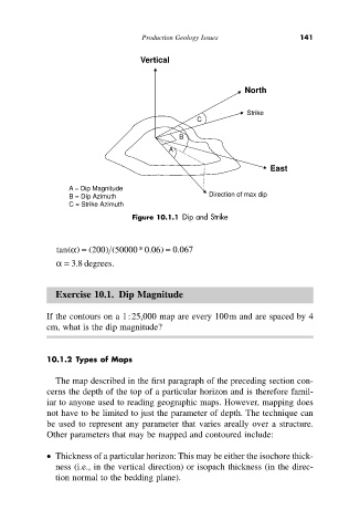
A = Dip Magnitude
B = Dip Azimuth Direction of max dip
C = Strike Azimuth
Figure 10.1.1 Dip and Strike
(
.
tan a) = ( 200) ( 50000*0.06) = 0 067
a = 3 .8 degrees.
Exercise 10.1. Dip Magnitude
If the contours on a 1:25,000 map are every 100m and are spaced by 4
cm, what is the dip magnitude?
10.1.2 Types of Maps
The map described in the first paragraph of the preceding section con-
cerns the depth of the top of a particular horizon and is therefore famil-
iar to anyone used to reading geographic maps. However, mapping does
not have to be limited to just the parameter of depth. The technique can
be used to represent any parameter that varies areally over a structure.
Other parameters that may be mapped and contoured include:
• Thickness of a particular horizon: This may be either the isochore thick-
ness (i.e., in the vertical direction) or isopach thickness (in the direc-
tion normal to the bedding plane).