
Page 192 - Well Logging and Formation Evaluation
P. 192
182 Well Logging and Formation Evaluation
200
180
160
140
AXDIR (deg) 120 AXDIR
100
HSDIR
80
60
40
20
0
960 980 1000 1020 1040 1060 1080 1100 1120 1140
Depth
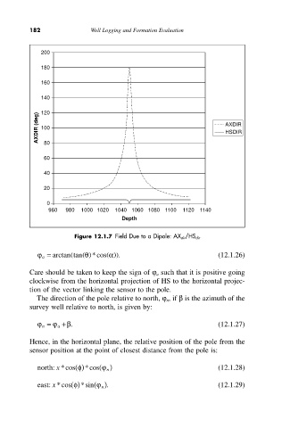
Figure 12.1.7 Field Due to a Dipole: AX dir/HS dir
j a = arctan (tan q ( )*cos ( a)). (12.1.26)
Care should be taken to keep the sign of j a such that it is positive going
clockwise from the horizontal projection of HS to the horizontal projec-
tion of the vector linking the sensor to the pole.
The direction of the pole relative to north, j n , if b is the azimuth of the
survey well relative to north, is given by:
j n = j a + b. (12.1.27)
Hence, in the horizontal plane, the relative position of the pole from the
sensor position at the point of closest distance from the pole is:
north: *cos f ( ) *cos j ( n ) (12.1.28)
x
east: *cos f ( ) *sin j ( n . ) (12.1.29)
x