
Page 59 - Moving the Earth_ The Workbook of Excavation
P. 59
SURVEYS AND MEASUREMENTS
SURVEYS AND MEASUREMENTS 2.9
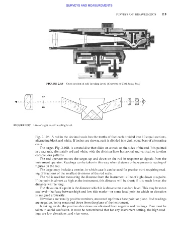
FIGURE 2.9B Cross section of self-leveling level. (Courtesy of Carl Zeiss, Inc.)
FIGURE 2.9C Line of sight in self-leveling level.
Fig. 2.10A. A rod in the decimal scale has the tenths of feet each divided into 10 equal sections,
alternating black and white. If inches are shown, each is divided into eight equal bars of alternating
color.
The target, Fig. 2.10B, is a metal disc that slides on a track on the sides of the rod. It is painted
in quadrants, alternately red and white, with the division lines horizontal and vertical, or in other
conspicuous patterns.
The rod operator moves the target up and down on the rod in response to signals from the
instrument operator. Readings can be taken in this way when distance or haze prevents reading of
figures on the rod.
The target may include a vernier, in which case it can be used for precise work requiring read-
ing of fractions of the smallest divisions of the rod scale.
The rod is used for measuring the distance from the instrument’s line of sight down to a point.
If the point is almost as high as the instrument, this distance will be short; if it is much lower, the
distance will be long.
The elevation of a point is the distance which it is above some standard level. This may be mean
sea level—halfway between high and low tide marks—or some local point to which an elevation
is assigned arbitrarily.
Elevations are usually positive numbers, measured up from a base point or plane. Rod readings
are negative, being measured down from the plane of the instrument.
In taking levels, the positive elevations are obtained from negative rod readings. Care must be
taken to avoid confusion. It must be remembered that for any instrument setting, the high read-
ings are low elevations, and vice versa.