
Page 63 - Moving the Earth_ The Workbook of Excavation
P. 63
SURVEYS AND MEASUREMENTS
SURVEYS AND MEASUREMENTS 2.13
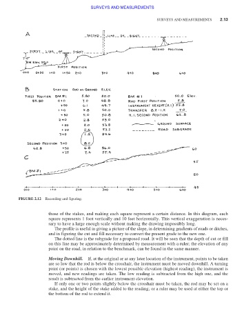
FIGURE 2.12 Recording and figuring.
those of the stakes, and making each square represent a certain distance. In this diagram, each
square represents 1 foot vertically and 10 feet horizontally. This vertical exaggeration is neces-
sary to have a large enough scale without making the drawing impossibly long.
The profile is useful in giving a picture of the slope, in determining gradients of roads or ditches,
and in figuring the cut and fill necessary to convert the present grade to the new one.
The dotted line is the subgrade for a proposed road. It will be seen that the depth of cut or fill
on this line may be approximately determined by measurement with a ruler; the elevation of any
point on the road, in relation to the benchmark, can be found in the same manner.
Moving Downhill. If, at the original or at any later location of the instrument, points to be taken
are so low that the rod is below the crosshair, the instrument must be moved downhill. A turning
point (or points) is chosen with the lowest possible elevation (highest reading), the instrument is
moved, and new readings are taken. The low reading is subtracted from the high one, and the
result is subtracted from the earlier instrument elevation.
If only one or two points slightly below the crosshair must be taken, the rod may be set on a
stake, and the height of the stake added to the reading; or a ruler may be used at either the top or
the bottom of the rod to extend it.