
Page 133 - Acquisition and Processing of Marine Seismic Data
P. 133
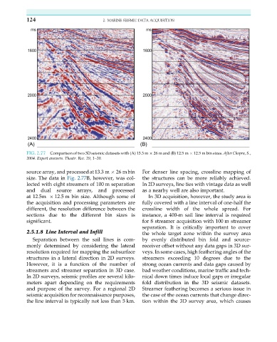
124                           2. MARINE SEISMIC DATA ACQUISITION


           FIG. 2.77  Comparison of two 3D seismic datasets with (A) 13.3 m   26 m and (B) 12.5 m   12.5 m bin sizes. After Chopra, S.,
           2004. Expert answers. Theatr. Rec. 29, 1–20.

           source array, and processedat13.3 m   26 mbin  For denser line spacing, crossline mapping of
           size. The data in Fig. 2.77B, however, was col-  the structures can be more reliably achieved.
           lected with eight streamers of 100 m separation  In 2D surveys, line ties with vintage data as well
           and   dual  source  arrays,  and  processed  as a nearby well are also important.
           at 12.5m   12.5 m bin size. Although some of    In 3D acquisition, however, the study area is
           the acquisition and processing parameters are  fully covered with a line interval of one-half the
           different, the resolution difference between the  crossline width of the whole spread. For
           sections due to the different bin sizes is   instance, a 400-m sail line interval is required
           significant.                                 for 8 streamer acquisition with 100 m streamer
                                                        separation. It is critically important to cover
           2.5.1.8 Line Interval and Infill             the whole target zone within the survey area
              Separation between the sail lines is com-  by evenly distributed bin fold and source-
           monly determined by considering the lateral  receiver offset without any data gaps in 3D sur-
           resolution required for mapping the subsurface  veys. In some cases, high feathering angles of the
           structures in a lateral direction in 2D surveys.  streamers exceeding 10 degrees due to the
           However, it is a function of the number of   strong ocean currents and data gaps caused by
           streamers and streamer separation in 3D case.  bad weather conditions, marine traffic and tech-
           In 2D surveys, seismic profiles are several kilo-  nical down times induce local gaps or irregular
           meters apart depending on the requirements   fold distribution in the 3D seismic datasets.
           and purpose of the survey. For a regional 2D  Streamer feathering becomes a serious issue in
           seismic acquisition for reconnaissance purposes,  the case of the ocean currents that change direc-
           the line interval is typically not less than 5 km.  tion within the 3D survey area, which causes