
Page 134 - Acquisition and Processing of Marine Seismic Data
P. 134
2.5 DATA ACQUISITION PARAMETERS 125
significant gaps across the contiguous sail lines Running the infill lines may become challenging
since the feathering angles may change by for far offsets since they are much more affected
means of amplitude and direction in such cases. by the ocean currents and hence feathering is
In order to compensate the uneven fold distri- more pronounced for the tail sections of the
butions or to fill in the gaps within the survey streamers. Acquisition with the fan mode layout
area, the vessel reshoots some of the lines after (Section 2.3.7) may significantly reduce the infill
primary 3D acquisition is completed. This addi- times for 3D surveys and hence reduces the
tional shooting is termed infill and it requires an overall cost of the survey.
additional survey design and sometimes signif-
icantly increases the survey costs, since they 2.5.1.9 Run-In and Run-Out Distances
may cover 15% of the total production time. In 2D and 3D surveys, shooting is initiated at
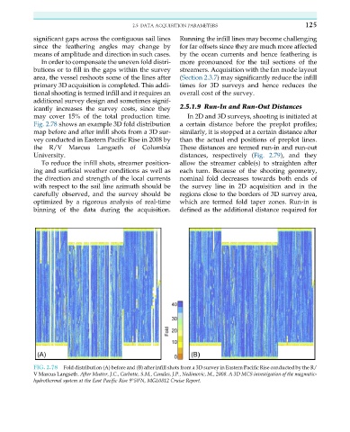
Fig. 2.78 shows an example 3D fold distribution a certain distance before the preplot profiles;
map before and after infill shots from a 3D sur- similarly, it is stopped at a certain distance after
vey conducted in Eastern Pacific Rise in 2008 by than the actual end positions of preplot lines.
the R/V Marcus Langseth of Columbia These distances are termed run-in and run-out
University. distances, respectively (Fig. 2.79), and they
To reduce the infill shots, streamer position- allow the streamer cable(s) to straighten after
ing and surficial weather conditions as well as each turn. Because of the shooting geometry,
the direction and strength of the local currents nominal fold decreases towards both ends of
with respect to the sail line azimuth should be the survey line in 2D acquisition and in the
carefully observed, and the survey should be regions close to the borders of 3D survey area,
optimized by a rigorous analysis of real-time which are termed fold taper zones. Run-in is
binning of the data during the acquisition. defined as the additional distance required for
FIG. 2.78 Fold distribution (A) before and (B) after infill shots from a 3D survey in Eastern Pacific Rise conducted by the R/
V Marcus Langseth. After Mutter, J.C., Carbotte, S.M., Canales, J.P., Nedimovic, M., 2008. A 3D MCS investigation of the magmatic-
hydrothermal system at the East Pacific Rise 9°50 N, MGL0812 Cruise Report.
0