
Page 139 - Acquisition and Processing of Marine Seismic Data
P. 139
130 2. MARINE SEISMIC DATA ACQUISITION
volume of the large seismic datasets may be Since the fold number has a significant effect
huge and sometimes pushes the hardware limits on the data quality, it is always preferred to
of the interpretation computers. This process, acquire high fold seismic data. In order to
however, reduces the dynamic range of the data. increase the fold, either the length of the
streamer(s) should be increased or the shot inter-
2.5.2.5 Optimum Fold val should be decreased according to Eq. (8.1).
Fold is defined as the number of traces in a The latter is more practical even though it may
CMP bin. The S/N ratio of the seismic data require the record length to be decreased. If
increases with the square root of the number of not, vessel speed should be decreased to keep
traces within the bins. As a general rule, 3D data the record length longer.
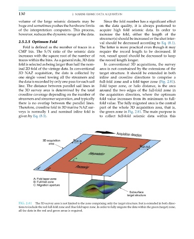
fold is selected as being larger than half the nom- In conventional 3D acquisitions, the survey
inal 2D fold of the vintage data. In conventional area is not constrained by the extensions of the
3D NAZ acquisition, the data is collected by target structure. It should be extended in both
one single vessel towing all the streamers and inline and crossline directions to comprise a
the data is recorded by only one pass for each sail full-fold zone and a fold taper zone (Fig. 2.81).
line. The distance between parallel sail lines in Fold taper zone, or halo distance, is the area
the 3D survey area is determined by the total around the two edges of the full-fold zone in
crossline coverage depending on the number of the acquisition direction, where the optimum
streamers and streamer separation, and typically fold value increases from its minimum to full-
there is no overlap between the parallel lines. fold value. The fully migrated area is the central
Therefore, crossline fold in 3D marine NAZ sur- part of the whole 3D acquisition area, that is,
veys is normally 1 and nominal inline fold is the green zone in Fig. 2.81. The main purpose is
given by Eq. (8.1). to collect full-fold seismic data within this
FIG. 2.81 The 3D survey area is not limited to the zone comprising only the target structure, but is extended in both direc-
tions to include the red full-fold zone and blue fold taper zone. In order to fully migrate the data within the green (target) zone,
all the data in the red and green areas is required.