
Page 147 - Acquisition and Processing of Marine Seismic Data
P. 147
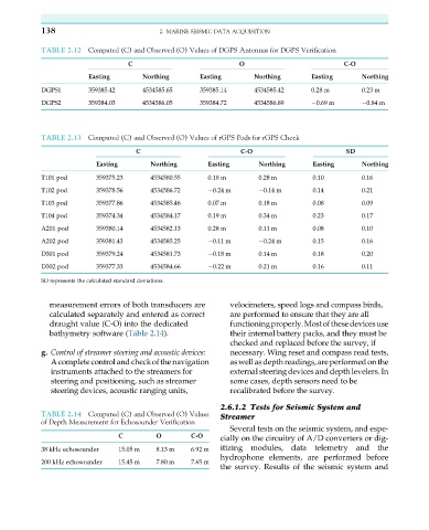
138                           2. MARINE SEISMIC DATA ACQUISITION

           TABLE 2.12  Computed (C) and Observed (O) Values of DGPS Antennas for DGPS Verification

                                 C                           O                         C-O
                       Easting       Northing      Easting       Northing      Easting      Northing
           DGPS1       359385.42     4534585.65    359385.14     4534585.42    0.28 m       0.23 m
           DGPS2       359384.03     4534586.05    359384.72     4534586.89     0.69 m       0.84 m


           TABLE 2.13  Computed (C) and Observed (O) Values of rGPS Pods for rGPS Check

                                   C                          C-O                       SD
                         Easting       Northing      Easting      Northing      Easting     Northing
           T101 pod      359375.23     4534580.55    0.18 m       0.28 m        0.10        0.16
           T102 pod      359378.56     4534586.72     0.24 m       0.14 m       0.14        0.21
           T103 pod      359377.86     4534585.46    0.07 m       0.18 m        0.08        0.09
           T104 pod      359374.34     4534584.17    0.19 m       0.34 m        0.23        0.17
           A201 pod      359380.14     4534582.13    0.28 m       0.11 m        0.08        0.10
           A202 pod      359381.43     4534585.25     0.11 m       0.24 m       0.15        0.16
           D301 pod      359379.24     4534581.73     0.18 m      0.14 m        0.18        0.20
           D302 pod      359377.33     4534584.66     0.22 m      0.21 m        0.16        0.11

           SD represents the calculated standard deviations.

             measurement errors of both transducers are    velocimeters, speed logs and compass birds,
             calculated separately and entered as correct  are performed to ensure that they are all
             draught value (C-O) into the dedicated        functioningproperly.Mostofthesedevicesuse
             bathymetry software (Table 2.14).             their internal battery packs, and they must be
                                                           checked and replaced before the survey, if
           g. Control of streamer steering and acoustic devices:  necessary. Wing reset and compass read tests,
              A completecontrol and check of the navigation  aswellasdepthreadings,areperformedonthe
              instruments attached to the streamers for    external steering devices and depth levelers. In
              steering and positioning, such as streamer   some cases, depth sensors need to be
              steering devices, acoustic ranging units,    recalibrated before the survey.
                                                        2.6.1.2 Tests for Seismic System and
           TABLE 2.14  Computed (C) and Observed (O) Values  Streamer
           of Depth Measurement for Echosounder Verification
                                                           Several tests on the seismic system, and espe-
                                                        cially on the circuitry of A/D converters or dig-
                               C        O        C-O
           38 kHz echosounder  15.05 m  8.13 m   6.92 m  itizing  modules,  data  telemetry  and  the
                                                        hydrophone elements, are performed before
           200 kHz echosounder  15.45 m  7.80 m  7.65 m
                                                        the survey. Results of the seismic system and