
Page 145 - Acquisition and Processing of Marine Seismic Data
P. 145
136 2. MARINE SEISMIC DATA ACQUISITION
2.6.1.1 Tests for Navigation System and and datum shifting. Typically, following con-
Components trols, calibrations and verifications of the navi-
The navigation system and all existing com- gation system and components are executed
ponents and sensors are checked and controlled before the initialization of the survey:
before the survey. Health checks of the naviga- • Setting up the navigation parameters
tion system and its components are carried out • Preparing streamer layout
onshore to verify that the installation of all the • Gyro calibration
equipment including DGPS receivers, gyros, • DGPS verification
motion sensor, echosounder, ADCP, etc., is com- • rGPS check
pleted accurately in terms of data receiving, • Echosounder depth data verification
transmission, and data logging, with the correct • Control of the streamer steering and acoustic
operational settings. Most of the calibrations and devices
verifications are based on the elimination of pos-
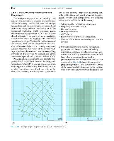
sible differences between accurately computed a. Navigation parameters: All the navigation
(C) and observed (O) values of the device read- parameters of the study area including
ings, which are then entered into the controlling ellipsoid, projection, UTM zone parameters
software of the devices to correct the errors and datum shifting are entered into the INS.
between computed and observed values (C-O). Preplots are prepared based on the
Preacquisition assessments also include pre- predetermined line name format and sail line
paring the plots of all sail lines on the integrated coordinates. Fig. 2.84 shows two example
navigation system (INS) known as preplot lines; preplot maps for 2D and 3D surveys. Offsets
assessing the possible major difficulties, such as of the vessel and all other navigation units as
weather conditions and local currents in the well as in-sea equipment with respect to the
area; and checking the navigation parameters
FIG. 2.84 Example preplot maps for (A) 2D and (B) 3D seismic survey.