
Page 416 - Automotive Engineering Powertrain Chassis System and Vehicle Body
P. 416
Global positioning technology C HAPTER 14.1
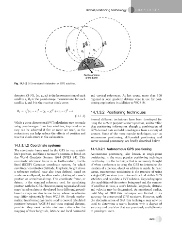
Fig. 14.1-2 3-Dimensional trilateration of GPS satellites.
detected (3–N), {x i , y i , z i } is the known position of each and vertical references. At last count, more than 100
satellite i, R i is the pseudorange measurement for each regional or local geodetic datums were in use for posi-
satellite i, and b is the receiver clock error: tioning applications in addition to WGS 84.
q ffiffiffiffiffiffiffiffiffiffiffiffiffiffiffiffiffiffiffiffiffiffiffiffiffiffiffiffiffiffiffiffiffiffiffiffiffiffiffiffiffiffiffiffiffiffiffiffiffiffiffiffiffiffiffiffiffiffiffiffiffiffiffiffiffi
2
2
2
R i ¼ ðx i xÞ þðy i yÞ þðz i zÞ b
14.1.3.2 Positioning techniques
(14.1.1)
Several different techniques have been developed for
While a three-dimensional PVTcalculation may be made using the GPS to pinpoint a user’s position, and to refine
using pseudoranges from four satellites, improved accu- that positioning information though a combination of
racy can be achieved if five or more are used, as the GPS-derived data and additional signals from a variety of
redundancy can help reduce the effects of position and sources. Some of the more popular techniques, such as
receiver clock errors in the calculation. autonomous positioning, differential positioning and
server-assisted positioning, are briefly described below.
14.1.3.1.2 Coordinate systems
The coordinate frame used by the GPS to map a satel- 14.1.3.2.1 Autonomous GPS positioning
lite’s position, and thus a receiver’s position, is based on Autonomous positioning, also known as single-point
the World Geodetic System 1984 (WGS 84). This positioning, is the most popular positioning technique
coordinate reference frame is an Earth-centred, Earth- used today. It is the technique that is commonly thought
fixed (ECEF) Cartesian coordinate system, for which of when a reference to using the GPS to determine the
curvilinear coordinates (latitude, longitude, height above location of a person, object or address is made. In basic
a reference surface) have also been defined, based on terms, autonomous positioning is the practice of using
a reference ellipsoid, to allow easier plotting of a user’s a single GPS receiver to acquire and track all visible GPS
position on a traditional map. This coordinate frame, or satellites, and calculate a PVTsolution. Depending upon
datum, is the standard reference used for calculating the capabilities of the system being used and the number
position with the GPS. However, many regional and local of satellites in view, a user’s latitude, longitude, altitude
maps based on datums developed from different ground- and velocity may be determined. As mentioned earlier,
based surveys are also in use today, whose coordinates until May of 2000 this technique was limited in its
may differ substantially from WGS 84. Simple mathe- accuracy for commercial GPS receivers. However, with
matical transformations can be used to convert calculated the discontinuation of S/A this technique may now be
positions between WGS 84 and these regional datums, used to determine a user’s location with a degree of
provided they meet certain minimum criteria for the accuracy and precision that was previously available only
mapping of their longitude, latitude and local horizontal to privileged users.
423