
Page 417 - Automotive Engineering Powertrain Chassis System and Vehicle Body
P. 417
CHAP TER 1 4. 1 Global positioning technology
14.1.3.2.2 Differential GPS positioning
The use of differential GPS (DGPS) has become popular
among GPS users requiring accuracies not previously
achievable with single-point positioning. DGPS effec-
tively eliminated the intentional errors of S/A, as well as
errors introduced as the satellite broadcasts pass through
the ionosphere and troposphere.
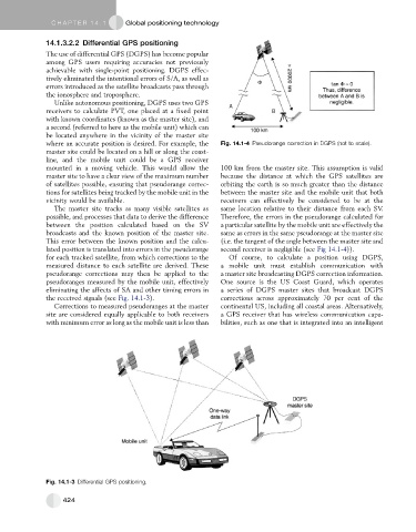
Unlike autonomous positioning, DGPS uses two GPS
receivers to calculate PVT, one placed at a fixed point
with known coordinates (known as the master site), and
a second (referred to here as the mobile unit) which can
be located anywhere in the vicinity of the master site
where an accurate position is desired. For example, the Fig. 14.1-4 Pseudorange correction in DGPS (not to scale).
master site could be located on a hill or along the coast-
line, and the mobile unit could be a GPS receiver
mounted in a moving vehicle. This would allow the 100 km from the master site. This assumption is valid
master site to have a clear view of the maximum number because the distance at which the GPS satellites are
of satellites possible, ensuring that pseudorange correc- orbiting the earth is so much greater than the distance
tions for satellites being tracked by the mobile unit in the between the master site and the mobile unit that both
vicinity would be available. receivers can effectively be considered to be at the
The master site tracks as many visible satellites as same location relative to their distance from each SV.
possible, and processes that data to derive the difference Therefore, the errors in the pseudorange calculated for
between the position calculated based on the SV a particular satellite by the mobile unit are effectively the
broadcasts and the known position of the master site. same as errors in the same pseudorange at the master site
This error between the known position and the calcu- (i.e. the tangent of the angle between the master site and
lated position is translated into errors in the pseudorange second receiver is negligible (see Fig 14.1-4)).
for each tracked satellite, from which corrections to the Of course, to calculate a position using DGPS,
measured distance to each satellite are derived. These a mobile unit must establish communication with
pseudorange corrections may then be applied to the a master site broadcasting DGPS correction information.
pseudoranges measured by the mobile unit, effectively One source is the US Coast Guard, which operates
eliminating the affects of SA and other timing errors in a series of DGPS master sites that broadcast DGPS
the received signals (see Fig. 14.1-3). corrections across approximately 70 per cent of the
Corrections to measured pseudoranges at the master continental US, including all coastal areas. Alternatively,
site are considered equally applicable to both receivers a GPS receiver that has wireless communication capa-
with minimum error as long as the mobile unit is less than bilities, such as one that is integrated into an intelligent
Fig. 14.1-3 Differential GPS positioning.
424