
Page 419 - Automotive Engineering Powertrain Chassis System and Vehicle Body
P. 419
CHAP TER 1 4. 1 Global positioning technology
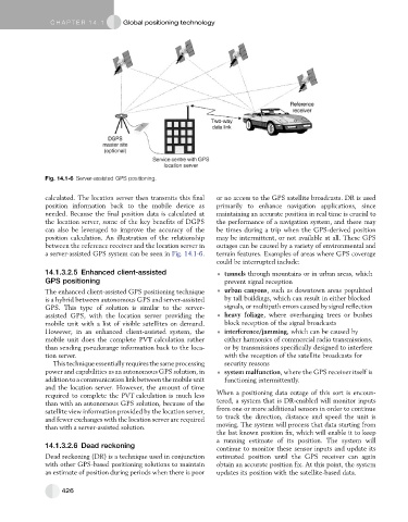
Fig. 14.1-6 Server-assisted GPS positioning.
calculated. The location server then transmits this final or no access to the GPS satellite broadcasts. DR is used
position information back to the mobile device as primarily to enhance navigation applications, since
needed. Because the final position data is calculated at maintaining an accurate position in real time is crucial to
the location server, some of the key benefits of DGPS the performance of a navigation system, and there may
can also be leveraged to improve the accuracy of the be times during a trip when the GPS-derived position
position calculation. An illustration of the relationship may be intermittent, or not available at all. These GPS
between the reference receiver and the location server in outages can be caused by a variety of environmental and
a server-assisted GPS system can be seen in Fig. 14.1-6. terrain features. Examples of areas where GPS coverage
could be interrupted include:
14.1.3.2.5 Enhanced client-assisted tunnels through mountains or in urban areas, which
GPS positioning prevent signal reception
The enhanced client-assisted GPS positioning technique urban canyons, such as downtown areas populated
is a hybrid between autonomous GPS and server-assisted by tall buildings, which can result in either blocked
GPS. This type of solution is similar to the server- signals, or multipath errors caused by signal reflection
assisted GPS, with the location server providing the heavy foliage, where overhanging trees or bushes
mobile unit with a list of visible satellites on demand. block reception of the signal broadcasts
However, in an enhanced client-assisted system, the interference/jamming, which can be caused by
mobile unit does the complete PVT calculation rather either harmonics of commercial radio transmissions,
than sending pseudorange information back to the loca- or by transmissions specifically designed to interfere
tion server. with the reception of the satellite broadcasts for
This technique essentially requires the same processing security reasons
power and capabilities as an autonomous GPS solution, in system malfunction, where the GPS receiver itself is
addition to a communication link between the mobile unit functioning intermittently.
and the location server. However, the amount of time
required to complete the PVT calculation is much less When a positioning data outage of this sort is encoun-
than with an autonomous GPS solution, because of the tered, a system that is DR-enabled will monitor inputs
satellite view information provided by the location server, from one or more additional sensors in order to continue
and fewer exchanges with the location server are required to track the direction, distance and speed the unit is
than with a server-assisted solution. moving. The system will process that data starting from
the last known position fix, which will enable it to keep
a running estimate of its position. The system will
14.1.3.2.6 Dead reckoning continue to monitor these sensor inputs and update its
Dead reckoning (DR) is a technique used in conjunction estimated position until the GPS receiver can again
with other GPS-based positioning solutions to maintain obtain an accurate position fix. At this point, the system
an estimate of position during periods when there is poor updates its position with the satellite-based data.
426