
Page 51 - Autonomous Mobile Robots
P. 51
34 Autonomous Mobile Robots
be classified as “dangerous” or “not dangerous.” Color cameras can be used to
perform terrain classification. Color segmentation relies on having a complete
training set. As lighting changes, due to time of day or weather conditions, the
appearance of grass and obstacle change as well. Although color normalization
methods have been successfully applied to the indoor environment, they, to
our knowledge, fail to produce reasonable results in an outdoor environment.
Similarly, color segmentation can classify flat objects, such as fallen leaves, as
obstacles, since their color is different from grass.
If dense range measurements in a scene are available (e.g., using ladar), they
can be used, not only to represent the scene geometry, but also to characterize
surface types. For example, the range measured on bare soil or rocks tends to
lie on a relatively smooth surface; in contrast, in the case of bushes, the range
is spatially scattered. While it is possible — although by no means trivial — to
design algorithms for terrain classification based on the local statistics of range
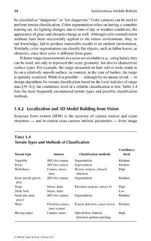
data [39–41], the confidence level of a reliable classification is low. Table 1.4
lists the most frequently encountered terrain types and possible classification
methods.
1.4.2 Localization and 3D Model Building from Vision
Structure from motion (SFM) is the recovery of camera motion and scene
structures — and in certain cases camera intrinsic parameters — from image
TABLE 1.4
Terrain Types and Methods of Classification
Confidence
Terrain type Sensors Classification methods level
Vegetable IR/Color camera Segmentation Medium
Rocks IR/Color camera Segmentation Medium
Walls/fence Camera, stereo, Texture analysis, obstacle High
laser detection
Road (paved, gravel, IR/Color camera Segmentation Medium
dirt)
Slope Stereo, ladar Elevation analysis, surface fit High
Ditch, hole Stereo, ladar Low
Sand, dirt, mud, IR/Color camera Segmentation Medium
gravel
Water Polarized camera, Feature detection, sensor fusion Medium
laser scanner
Moving target Camera, stereo Optical flow, obstacle High
detection, pattern matching
© 2006 by Taylor & Francis Group, LLC
FRANKL: “dk6033_c001” — 2006/3/31 — 16:42 — page 34 — #34