
Page 63 - Encyclopedia Of World History Vol IV
P. 63
1364 berkshire encyclopedia of world history
The marksman hitteth the target partly by pulling, partly by letting go. The boatsman
reached the landing partly by pulling, partly by letting go. • Egyptian proverb
seasonal changes, sea and tidal currents, and water depths Navigation in the Ancient
and the capability to estimate the sailing time between World
various ports. Distinction should be made between Navigational methods and techniques were developed
coastal and ocean navigation. Coastal navigation is prac- independently in several parts of the world. From draw-
ticed within sight of land, and orientation is provided by ings in pyramids it is known that Egyptian seamen used
data such as the profile of the coastline, knowledge of con- sounding rods to measure the water depth beneath their
spicuous landmarks, water depth, and local sea currents. vessels.When Persian and Arabian mariners sailed across
When sailing across a large stretch of water beyond sight the Indian Ocean, and, roughly from the eighth century
of the coast, a mariner will register his approximate posi- CE, toward China, they used a wind rose for orientation,
tion by dead reckoning. This is the method by which a based on the points of rising and setting of fixed stars.
ship’s position is estimated by using the knowledge of the Latitude was estimated by observing the altitude of the
position at departure, the steered courses, and the dis- sun and the polestar. In the ninth century, in some parts
tances made good since departure. Because a number of of the Indian Ocean, shore-sighting pigeons were used
uncertain factors influence these calculations, the resulting on Persian ships to set course to the nearest land.Around
position is not entirely reliable.The uncertain factors are 650 CE Arabs, who were experienced in finding their way
the speed and direction of sea currents and leeway, which in the desert by observing stars, used a compass rose of
is the angle between the course steered by the compass which the points were named after the points of rising
and the course made good, caused by the wind pushing and setting of fixed stars.The lodestone, with which iron
the ship sideways. During a voyage the error caused by can be magnetized so that it points toward the north,
these factors cumulates so that the fault in a dead- was not used by Arab and Persian navigators before the
reckoned position can become considerable, and lead to end of the eleventh century. By the fifteenth century Arab
a dangerous situation. An exact position, a “fix,” can be seamen used the kamal, an instrument for measuring the
found by observing celestial bodies, a calculation, and a altitude of celestial bodies, to estimate their latitude.
subsequent construction in the sea chart. Sailors from islands in the South Seas traditionally
Practical navigation is called seamanship, and includes crossed large stretches of ocean using a “wind compass,”
the knowledge how to handle a ship and its rigging and with which the directions of islands were defined by the
sails and maneuvering the vessel. Seamanship is not character of the wind, e.g., moist, dry, hard, or gentle.
dealt with in this article. Their “star compass” was defined by the directions in
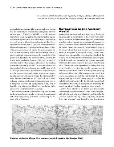
Chinese navigator Zheng He’s compass guided chart to the Persian Gulf.