
Page 66 - Encyclopedia Of World History Vol IV
P. 66
navigation 1367
viga
n
1367
a
tion
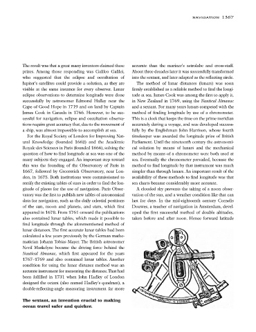
The result was that a great many inventors claimed these accurate than the mariner’s astrolabe and cross-staff.
prizes. Among those responding was Galileo Galilei, About three decades later it was successfully transformed
who suggested that the eclipse and occultation of into the sextant, and later adapted as the reflecting circle.
Jupiter’s satellites could provide a solution, as they are The method of lunar distances (lunars) was soon
visible at the same instance for every observer. Lunar firmly established as a reliable method to find the longi-
eclipse observations to determine longitude were done tude at sea. James Cook was among the first to apply it,
successfully by astronomer Edmond Halley near the in New Zealand in 1769, using the Nautical Almanac
Cape of Good Hope in 1719 and on land by Captain and a sextant. For many years lunars competed with the
James Cook in Canada in 1766. However, to be suc- method of finding longitude by use of a chronometer.
cessful for navigation, eclipse and occultation observa- This is a clock that keeps the time on the prime meridian
tions require great accuracy that, due to the movement of accurately during a voyage, and was developed success-
a ship, was almost impossible to accomplish at sea. fully by the Englishman John Harrison, whose fourth
For the Royal Society of London for Improving Nat- timekeeper was awarded the longitude prize of British
ural Knowledge (founded 1662) and the Académie Parliament. Until the nineteenth century the astronomi-
Royale des Sciences in Paris (founded 1666), solving the cal solution by means of lunars and the mechanical
question of how to find longitude at sea was one of the method by means of a chronometer were both used at
many subjects they engaged. An important step toward sea. Eventually the chronometer prevailed, because the
this was the founding of the Observatory of Paris in method to find longitude by that instrument was much
1667, followed by Greenwich Observatory, near Lon- simpler than through lunars. An important result of the
don, in 1675. Both institutions were commissioned to availability of these methods to find longitude was that
rectify the existing tables of stars in order to find the lon- sea charts became considerably more accurate.
gitude of places for the use of navigation. Paris Obser- A clouded sky prevents the taking of a noon obser-
vatory was the first to publish new tables of astronomical vation of the sun, and a weather condition like that can
data for navigation, such as the daily celestial positions last for days. In the mid-eighteenth century Cornelis
of the sun, moon and planets, and stars, which first Douwes, a teacher of navigation in Amsterdam, devel-
appeared in 1678. From 1761 onward the publications oped the first successful method of double altitudes,
also contained lunar tables, which made it possible to taken before and after noon. Hence forward latitude
find longitude through the aforementioned method of
lunar distances.The first accurate lunar tables had been
calculated a few years previously by the German mathe-
matician Johann Tobias Mayer. The British astronomer
Nevil Maskelyne became the driving force behind the
Nautical Almanac, which first appeared for the years
1767–1769 and also contained lunar tables. Another
condition for using the lunar distance method was an
accurate instrument for measuring the distance.That had
been fulfilled in 1731 when John Hadley of London
designed the octant (also named Hadley’s quadrant), a
double-reflecting-angle measuring instrument far more
The sextant, an invention crucial to making
ocean travel safer and quicker.