
Page 202 - Carbonate Facies in Geologic History
P. 202
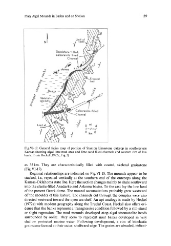
Platy Algal Mounds in Basins and on Shelves                       189


                                                      ..
                                                     '*
                                                     (J
                                                     o   ;1
                                                    ...  .... ;1  <J;'
                                                    '"  '"
                                              ................  r
                                            .........  .... ,. ....
                                           ...  "' ....
                                         .... ; .........
                                            Calcarenite - filled
                                            Channel


               Fig. VI -17.  General  facies  map  of portion  of  Stanton  Limestone  outcrop  in  southwestern
               Kansas showing algal lime mud area and lime sand filled  channels and western rim  of low
               bank. From Heckel (1972c, Fig. 2)

               as  35 km.  They  are  characteristically  filled  with  coated,  skeletal  grainstone
               (Fig. VI  -17).
                  Regional relationships are indicated on Fig.VI-18. The mounds appear to be
               stacked,  i.e.,  repeated  vertically  at  the  southern  end  of the  outcrops  along  the
               Kansas-Oklahoma state line. Here the section changes mainly to shale southward
               into the clastic-filled Anadarko and Arkoma basins. To the east lay the low land
               of the present Ozark dome. The mound accumulations probably grew westward
               off the shoulder of this feature. The channels cut through the complex were also
               directed westward toward the open sea shelf.  An  apt analogy is  made by Heckel
               (1972c) with modern geography along the Trucial Coast. Heckel also offers evi-
               dence that the banks represent a transgressive condition followed by a still-stand
               or slight regression.  The  mud  mounds developed  atop algal  stromatolite heads
               surrounded  by  oolite.  They  seem  to  represent  mud  banks  developed  in  very
               shallow  protected  marine  water.  Following  development,  a  rim  of  bioclastic
               grainstone formed at their outer, shelfward edge. The grains are abraded, indicat-