
Page 83 - Concise Encyclopedia of Robotics
P. 83
Depth Map
of obstacles or changes in the work environment. Deliberative planning
is commonly combined with another scheme called reactive planning.
See also HIERARCHICAL PARADIGM, HYBRID DELIBERATIVE/REACTIVE PARADIGM, and REACTIVE
PARADIGM.
DEPTH MAP
A depth map, also called a range image, is a specialized form of computer
map, rendered as a grayscale image of a robot’s work environment. The
brightness of each pixel (picture element) in the image is proportional to
the range, or radial distance, to the nearest obstruction in a specific direc-
tion. In some depth maps, the brightest pixels correspond to short range;
in others, the brightest pixels correspond to long range.
A typical range image looks something like a grayscale video image or its
negative. However, upon examination, the difference between a conven-
tional visible or infrared (IR) image and a depth map becomes apparent.
Local detail in objects, such as the contour of a human face, generally do
not show up in a depth map, even if the shade, color, or heat radiation
vary greatly. It is the radial distance, as determined by a range sensing and
plotting system, which produces the image.
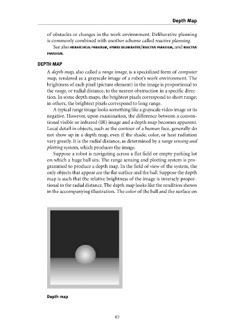
Suppose a robot is navigating across a flat field or empty parking lot
on which a huge ball sits. The range sensing and plotting system is pro-
grammed to produce a depth map. In the field of view of the system, the
only objects that appear are the flat surface and the ball. Suppose the depth
map is such that the relative brightness of the image is inversely propor-
tional to the radial distance. The depth map looks like the rendition shown
in the accompanying illustration. The color of the ball and the surface on
Depth map
