
Page 181 - Digital Analysis of Remotely Sensed Imagery
P. 181
146 Cha pte r F i v e
covers a massive swath width of 2400 km per scene, the distortion is
substantial. This systematic error can be calculated using Eq. (5.1).
L = 2r × sin (H × tan(FOV/2)/R) (5.1)
−1
where L = actual length of the Earth’s surface covered by the image
after taking its curvature into consideration
r = radius of the Earth or (6370 km)
H = height of the satellite, usually in the range of hundreds of
kilometers, for AVHRR data, it is 833 km (see Sec. 2.3).
The discrepancy between the flat and curved dimension is
ΔL = L − D = L − 2H × tan(FOV/2) (5.2)
Example
H = 833 km, r = 6370 km, D = 2400 km
f = sin (D/2/R) = sin (2400/2/6370) = 10.858°
−1
−1
ΔL = L − D = 6370 × 2 × (10.858 × 3.14159)/180 − 2400 = 14 km
Thus, there is a discrepancy of 14 km in the image swath width
caused by Earth curvature.
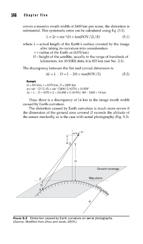
The distortion caused by Earth curvature is much more severe if
the dimension of the ground area covered D exceeds the altitude of
the sensor markedly, as is the case with aerial photography (Fig. 5.3).
Δr
r
f
O
H
Ground coverage
A′ Map plane
h
A Earth’s surface
R
FIGURE 5.3 Distortion caused by Earth curvature on aerial photographs.
(Source: Modifi ed from Zhou and Jezek, 2004.)