
Page 180 - Digital Analysis of Remotely Sensed Imagery
P. 180
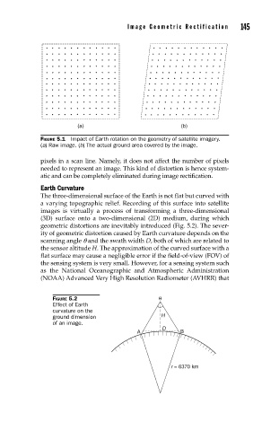
Image Geometric Rectification      145


                           (a)                            (b)

               FIGURE 5.1  Impact of Earth rotation on the geometry of satellite imagery.
               (a) Raw image. (b) The actual ground area covered by the image.

               pixels in a scan line. Namely, it does not affect the number of pixels
               needed to represent an image. This kind of distortion is hence system-
               atic and can be completely eliminated during image rectification.
               Earth Curvature
               The three-dimensional surface of the Earth is not flat but curved with
               a varying topographic relief. Recording of this surface into satellite
               images is virtually a process of transforming a three-dimensional
               (3D) surface onto a two-dimensional (2D) medium, during which
               geometric distortions are inevitably introduced (Fig. 5.2). The sever-
               ity of geometric distortion caused by Earth curvature depends on the
               scanning angle q and the swath width D, both of which are related to
               the sensor altitude H. The approximation of the curved surface with a
               flat surface may cause a negligible error if the field-of-view (FOV) of
               the sensing system is very small. However, for a sensing system such
               as the National Oceanographic and  Atmospheric  Administration
               (NOAA) Advanced Very High Resolution Radiometer (AVHRR) that


                   FIGURE 5.2                       θ
                   Effect of Earth
                   curvature on the
                   ground dimension                 H
                   of an image.
                                                    D
                                             A            B


                                                       r = 6370 km