
Page 183 - Digital Analysis of Remotely Sensed Imagery
P. 183
148 Cha pte r F i v e
longer. On the other hand, the scanning instantaneous field-of-view
(IFOV) (Δq ) remains constant irrespective of the scan angle q. Therefore,
a larger area on the ground is covered by the same scanning IFOV
further away from the nadir. In the obtained imagery, this increased
ground is recorded at the same dimension as the nadir ground because
of the fixed focal length, resulting in off-nadir image compression. The
further away an object is from the nadir position, the larger the compres-
sion. This scan-direction distortion is called tangential scale distortion.
Tangential scale distortion is a systematic error that can be calcu-
lated using the following formula. As shown in Fig. 5.4,
AC = Δq ⋅ H (5.4)
A
ΔY = AC (5.5)
cosθ
H= H 0 (5.6)
A
cosθ
AC = Δθ H 0 (5.7)
cos θ
Δy Δθ ⋅ f Δθ ⋅ f f f
Scale = = = cos θ = cos θ (5.8)
2
ΔY Δθ ⋅ H Δθ ⋅ H H
A 0 0
cos θ cos θ
where f/H represents the nadir scale. Scale distortion occurs at a rate
0
2
of cos q in the cross-track direction. Of particular note is that tangen-
tial scale distortion occurs only in the direction perpendicular to the
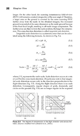
flight direction (Fig. 5.5). Along the flight direction there is no such
distortion. Consequently, regular shapes of grids, diamonds, and
circles on the ground (Fig. 5.5a) are no longer regular in the acquired
Constant lateral scale Varying lateral scale direction
Flight
Constant longitudinal scale
Constant longitudinal scale
(a) (b)
FIGURE 5.5 The degree of compression in the fl ight direction and across the
track. (Source: modifi ed from Lillesand et al., 2003.)