
Page 188 - Digital Analysis of Remotely Sensed Imagery
P. 188
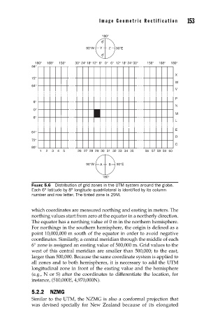
Image Geometric Rectification      153

                                           180°
                                           6 °
                                     90°W  Y  Z  90°E
                                           6 °
                 180°  168°  156°  30°  24° 18° 12°  6°  0° 6°  12°  18°  24° 30°  156°  168°  180°
               84°
                                                                        X
               72°
                                                                        W
               64°
                                                                        V
                                                                        P
                6°
                                                                        N
                0°
                                                                        M
                6°
                                                                        L
               64°                                                      E
                                                                        D
               72°
                                                                        C
               80°
                   1  2  3  4  5  26 27 28 29 30 31 32 33 34 35  56 57 58 59 60

                                     90°W  A  B  90°E

                                           180°
               FIGURE 5.6  Distribution of grid zones in the UTM system around the globe.
               Each 6° latitude by 8° longitude quadrilateral is identifi ed by its column
               number and row letter. The tinted zone is 29M.


               which coordinates are measured northing and easting in meters. The
               northing values start from zero at the equator in a northerly direction.
               The equator has a northing value of 0 m in the northern hemisphere.
               For northings in the southern hemisphere, the origin is defined as a
               point 10,000,000 m south of the equator in order to avoid negative
               coordinates. Similarly, a central meridian through the middle of each
               6° zone is assigned an easting value of 500,000 m. Grid values to the
               west of this central meridian are smaller than 500,000; to the east,
               larger than 500,000. Because the same coordinate system is applied to
               all zones and to both hemispheres, it is necessary to add the UTM
               longitudinal zone in front of the easting value and the hemisphere
               (e.g., N or S) after the coordinates to differentiate the location, for
               instance, (510,000E, 4,970,000N).

               5.2.2 NZMG
               Similar to the UTM, the NZMG is also a conformal projection that
               was devised specially for New Zealand because of its elongated