
Page 193 - Digital Analysis of Remotely Sensed Imagery
P. 193
158 Cha pte r F i v e
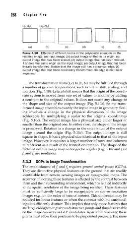
(r 0 , c 0 ) (E 0 ,N 0 )
(a) (b) (c) (d) (e) (f)
FIGURE 5.10 Effects of different terms in the polynomial equation on the
rectifi ed image. (a) Input image; (b) output image shifted in its origin; (c)
output image that has been scaled; (d) output image that has been rotated.
It shares the same origin as the input image; (e) output image that has been
linearly transformed. Notice that the image still has a clear-cut edge; (f)
output image that has been nonlinearly transformed. Its edge is not linear
anymore.
The transformation from (r, c) to (E, N) may be fulfilled through
a number of geometric operations, such as lateral shift, scaling, and
rotation (Fig. 5.10). Lateral shift means that the origin of the coordi-
nate system is moved from one set of values to another by adding
a constant to the original values. It does not cause any change to
the shape and size of the output image (Fig. 5.10b). So the trans-
formed image resembles exactly the input image in geometry. Scal-
ing involves a change in the physical dimension of the image
achievable by multiplying a scalar to the original coordinates
(Fig. 5.10c). The output image has a physical size either larger or
smaller than the original one. In either case, the shape of the image
is preserved. Rotation is a change in the orientation of the output
image around the origin (Fig. 5.10d). The output image is still
square in shape. It has a physical size identical to that of the input
image. However, it requires a larger number of rows and columns
to represent as a result of the rotated orientation. The shape of the
rectified output image may no longer be regular (Fig. 5.10e and f ) if
f and f are nonlinear.
1 2
5.3.3 GCPs in Image Transformation
The establishment of f and f requires ground control points (GCPs).
1 2
They are distinctive physical features on the ground that are readily
identifiable from remote sensing images or topographic maps. The
accuracy of locating these features is affected by the contrast between
them and their surrounding environment, which is related indirectly
to the spatial resolution of the image being rectified. These features
must be sufficiently large to be recognizable on coarse resolution
images (e.g., on the order of tens of meters). This dimension may be
reduced for linear features or when the contrast with the surround-
ings is sufficiently distinct. This implies that only those features that
are large enough to register as distinctive points and thus discernable
on the image can serve as GCP candidates. Apart from visibility, these
points must allow their positions to be pinpointed precisely. The more