
Page 194 - Digital Analysis of Remotely Sensed Imagery
P. 194
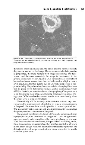
Image Geometric Rectification      159


               FIGURE 5.11  Exemplary points (arrows) that can serve as reliable GCPs.
               These points are easy to identify on satellite imagery, and their positions can
               be pinpointed accurately.

               distinctive these landmarks are, the easier and the more accurately
               they can be located on the image. The more accurately their position
               is pinpointed, the more reliable their image coordinates are deter-
               mined, and the more accurately the image is transformed to the
               ground coordinate system. Quality GCP candidates are exemplified
               by road and street intersections that can be located at a high accuracy
               level (Fig. 5.11). Another quality that all GCPs should possess is tem-
               poral stability. They should not have moved since imaging if the loca-
               tion is going to be determined using a global positioning system
               (GPS) in the field, or since the day of photographing if the position is
               to be determined from a topographic map compiled from aerial pho-
               tographs. GCPs based on land-water interface are useable only when
               the water level is temporarily stable.
                   Theoretically, GCPs are only point features without any area.
               However, the minimum unit identifiable on remote sensing imagery
               is the pixel. No matter how small a pixel is, it covers a ground area.
               The incongruity between point and area is reconciled by interpreting
               the point position as the center of the pixel.
                   The ground coordinates (E, N) of GCPs can be determined from
               topographic maps or measured on the ground. Their image coordi-
               nates are usually determined from the image displayed on a screen.
               With these two sets of coordinates, it is possible to establish f  and f .
                                                                   1    2
               Once the equations are established, they are then applied to all pixels
               in the input image. With the established transform equations, the
               distortion-infected image coordinates (r, c) are converted to mostly
               error-free global ones.