
Page 234 - Digital Analysis of Remotely Sensed Imagery
P. 234
198 Cha pte r F i v e
unknown. The subset image is always square or rectangular in
shape, covering a smaller area than that of the input image. The area
falling outside the defined bound is discarded. There is no limit to
the number of spectral bands in the input image. The number of
output bands is usually kept the same as that of the input image.
If the satellite images have been georeferenced to a global system
already, it is more appropriate to subset the area of interest using a
polygon known as area of interest (AOI) in ERDAS. This polygon
file can be imported from an existing GIS database or digitized man-
ually on screen. Its intersection with the input image enables a
subimage to be cut out. Unlike the row/column number method, an
irregularly shaped polygon allows the study area to be defined more
precisely than a regular square or rectangle (Fig. 5.24). Images subset
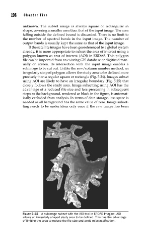
using AOI are likely to have an irregular boundary (Fig. 5.25) that
closely follows the study area. Image subsetting using AOI has the
advantage of a reduced file size and less processing in subsequent
steps as the background, rendered as black in the figure, is automat-
ically excluded from analysis. In terms of data storage, less space is
needed as all background has the same value of zero. Image subset-
ting needs to be undertaken only once if the raw image has been
FIGURE 5.25 A subimage subset with the AOI tool in ERDAS Imagine. AOI
allows an irregularly shaped study area to be defi ned. This has the advantage
of limiting the area to reduce the fi le size and avoid misclassifi cation.