
Page 237 - Digital Analysis of Remotely Sensed Imagery
P. 237
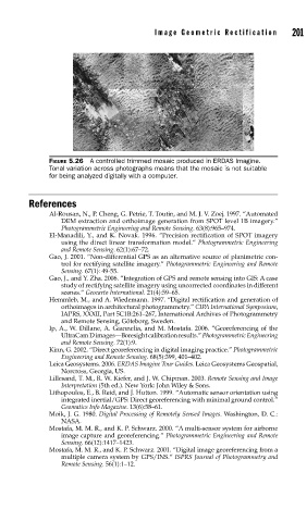
Image Geometric Rectification      201


               FIGURE 5.26  A controlled trimmed mosaic produced in ERDAS Imagine.
               Tonal variation across photographs means that the mosaic is not suitable
               for being analyzed digitally with a computer.


          References
               Al-Rousan, N., P. Cheng, G. Petrie, T. Toutin, and M. J. V. Zoej. 1997. “Automated
                  DEM extraction and orthoimage generation from SPOT level 1B imagery.”
                  Photogrammetric Engineering and Remote Sensing. 63(8):965–974.
               El-Manadili, Y., and K. Novak. 1996. “Precision rectification of SPOT imagery
                  using the direct linear transformation model.” Photogrammetric Engineering
                  and Remote Sensing. 62(1):67–72.
               Gao, J. 2001. “Non-differential GPS as an alternative source of planimetric con-
                  trol for rectifying satellite imagery.” Photogrammetric Engineering and Remote
                  Sensing. 67(1): 49-55.
               Gao, J., and Y. Zha. 2006. “Integration of GPS and remote sensing into GIS: A case
                  study of rectifying satellite imagery using uncorrected coordinates in different
                  scenes.” Geocarto International. 21(4):59–65.
               Hemmleb, M., and A. Wiedemann. 1997. “Digital rectification and generation of
                  orthoimages in architectural photogrammetry.” CIPA International Symposium,
                  IAPRS, XXXII, Part 5C1B:261–267, International Archives of Photogrammetry
                  and Remote Sensing, Göteborg, Sweden.
               Ip, A., W. Dillane, A. Giannelia, and M. Mostafa. 2006. “Georeferencing of the
                  UltraCam D images—Boresight calibration results.” Photogrammetric Engineering
                  and Remote Sensing. 72(1):9.
               Kinn, G. 2002. “Direct georeferencing in digital imaging practice.” Photogrammetric
                  Engineering and Remote Sensing. 68(5):399, 401–402.
               Leica Geosystems. 2006. ERDAS Imagine Tour Guides. Leica Geosystems Geospatial,
                  Norcross, Georgia, US.
               Lillesand, T. M., R. W. Kiefer, and J. W. Chipman. 2003. Remote Sensing and Image
                  Interpretation (5th ed.). New York: John Wiley & Sons.
               Lithopoulos, E., B. Reid, and J. Hutton. 1999. “Automatic sensor orientation using
                  integrated inertial/GPS: Direct georeferencing with minimal ground control.”
                  Geomatics Info Magazine. 13(6):58–61.
               Moik, J. G. 1980. Digital Processing of Remotely Sensed Images. Washington, D. C.:
                  NASA.
               Mostafa, M. M. R., and K. P. Schwarz. 2000. “A multi-sensor system for airborne
                  image capture and georeferencing.” Photogrammetric Engineering and Remote
                  Sensing. 66(12):1417–1423.
               Mostafa, M. M. R., and K. P. Schwarz. 2001. “Digital image georeferencing from a
                  multiple camera system by GPS/INS.” ISPRS Journal of Photogrammetry and
                  Remote Sensing. 56(1):1–12.