
Page 34 - Digital Analysis of Remotely Sensed Imagery
P. 34
Overview 7
Satellite data Analog photos/images
Preprocessing Scanning
Remotely sensed data
Image subsetting
Topo.map (GPS) data Georeferencing
Image transformation
Enhancement Feature selection
Image classification
Manual interpretation Spectral per-pixel classification
Subpixel image classification
Fuzzy image classification
Spatial image classification
Object-oriented classification
Knowledge-based classification
Postclassification Ancillary data
Accuracy assessment
processing
Output (maps,
reports, data) Change detection Modeling GIS
GPS
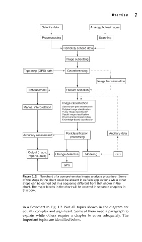
FIGURE 1.2 Flowchart of a comprehensive image analysis procedure. Some
of the steps in the chart could be absent in certain applications while other
steps can be carried out in a sequence different from that shown in the
chart. The major blocks in the chart will be covered in separate chapters in
this book.
in a flowchart in Fig. 1.2. Not all topics shown in the diagram are
equally complex and significant. Some of them need a paragraph to
explain while others require a chapter to cover adequately. The
important topics are identified below.