
Page 37 - Digital Analysis of Remotely Sensed Imagery
P. 37
10 Cha pte r O n e
245 233 247 274 344 306 293 304 325
269 240 251 260 332 263 229 259 324
305 268 230 234 259 273 245 251 258
305 258 310 259 276 351 372 279 285
331 218 454 386 557 822 616 347 263
544 270 383 851 820 674 442 305 246
666 380 253 431 342 291 397 384 252
390 319 254 246 256 337 332 267 361
246 253 258 255 271 440 375 238 321
239 252 260 295 329 358 362 516 515
445 377 241 352 492 552 441 525 604
536 490 299 350 473 610 453 288 513
447 487 349 274 420 592 511 315 426
317 307 281 308 512 521 542 319 428
258 258 258 244 365 357 457 307 368
314 295 311 277 237 262 289 321 268
297 262 280 286 285 276 289 295 338
294 427 378 297 274 291 289 295 287
280 272 274 279 298 289 306 315 305
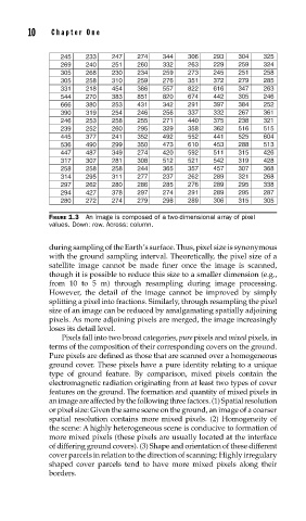
FIGURE 1.3 An image is composed of a two-dimensional array of pixel
values. Down: row. Across: column.
during sampling of the Earth’s surface. Thus, pixel size is synonymous
with the ground sampling interval. Theoretically, the pixel size of a
satellite image cannot be made finer once the image is scanned,
though it is possible to reduce this size to a smaller dimension (e.g.,
from 10 to 5 m) through resampling during image processing.
However, the detail of the image cannot be improved by simply
splitting a pixel into fractions. Similarly, through resampling the pixel
size of an image can be reduced by amalgamating spatially adjoining
pixels. As more adjoining pixels are merged, the image increasingly
loses its detail level.
Pixels fall into two broad categories, pure pixels and mixed pixels, in
terms of the composition of their corresponding covers on the ground.
Pure pixels are defined as those that are scanned over a homogeneous
ground cover. These pixels have a pure identity relating to a unique
type of ground feature. By comparison, mixed pixels contain the
electromagnetic radiation originating from at least two types of cover
features on the ground. The formation and quantity of mixed pixels in
an image are affected by the following three factors. (1) Spatial resolution
or pixel size: Given the same scene on the ground, an image of a coarser
spatial resolution contains more mixed pixels. (2) Homogeneity of
the scene: A highly heterogeneous scene is conducive to formation of
more mixed pixels (these pixels are usually located at the interface
of differing ground covers). (3) Shape and orientation of these different
cover parcels in relation to the direction of scanning: Highly irregulary
shaped cover parcels tend to have more mixed pixels along their
borders.