
Page 262 - Earth's Climate Past and Future
P. 262
238 PART IV • Deglacial Climate Changes
lockstep (see Figure 11–17). This very close timing sug-
gests that the greenhouse-gas concentrations were Hudson Bay
largely controlled by the ice sheets and that the gases
provided positive feedback to the process of ice melting.
Some climate scientists contest this north-centered
view of the deglaciation. They note that evidence for even Glacial
earlier deglacial warming responses can be found in the Lake
tropics and near Antarctica. Such evidence can be inter- Agassiz
preted to indicate that the tropics or south polar region
act as sensitive early triggers of melting in the north. Glacial Lake
Ojibway
13-5 Deglacial Lakes, Floods, and Sea Level Rise
Lake Superior
As the ice sheets melted back, the land in front of them
remained depressed for some time rather than immediately
rebounding to its former (ice-free) level (Chapter 9). Into
these depressions poured meltwater from the retreating
ice sheets, forming proglacial lakes. Because of the large A Total area covered by deglacial lakes
volumes of meltwater arriving each summer, the lakes fre- Hudson Hudson
quently cut new channels and overflowed into other lakes Bay Bay
and then into rivers that carried water to the ocean.
The proglacial lakes existed in a highly dynamic
landscape (Figure 13–9). As deglaciation proceeded, the
ice margins fluctuated, with lobes of ice retreating
and sliding forward but gradually shrinking farther and
farther back over time. Each time the ice lobes retreated,
B Lakes during deglaciation
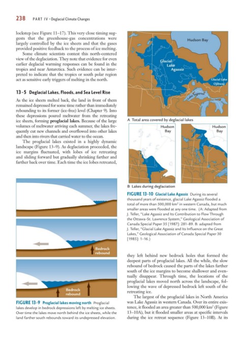
FIGURE 13-10 Glacial Lake Agassiz During its several
thousand years of existence, glacial Lake Agassiz flooded a
2
total of more than 500,000 km in western Canada, but much
smaller areas were flooded at any one time. (A: Adapted from
J. Teller, “Lake Agassiz and Its Contribution to Flow Through
the Ottawa–St. Lawrence System,” Geological Association of
Canada Special Paper 35 [1987]: 281–89. B: adapted from
J. Teller, “Glacial Lake Agassiz and Its Influence on the Great
Lakes,” Geological Association of Canada Special Paper 30
[1985]: 1–16.)
Bedrock
rebound
they left behind new bedrock holes that formed the
deepest parts of proglacial lakes. All the while, the slow
rebound of bedrock caused the parts of the lakes farther
south of the ice margins to become shallower and even-
tually disappear. Through time, the locations of the
proglacial lakes moved north across the landscape, fol-
lowing the wave of depressed bedrock left south of the
Bedrock retreating ice.
rebound
The largest of the proglacial lakes in North America
FIGURE 13-9 Proglacial lakes moving north Proglacial was Lake Agassiz in western Canada. Over its entire exis-
2
lakes develop in bedrock depressions left by melting ice sheets. tence, it flooded an area greater than 500,000 km (Figure
Over time the lakes move north behind the ice sheets, while the 13–10A), but it flooded smaller areas at specific intervals
land farther south rebounds toward its undepressed elevation. during the ice retreat sequence (Figure 13–10B). At its