
Page 265 - Earth's Climate Past and Future
P. 265
CHAPTER 13 • Climate During and Since the Last Deglaciation 241
BOX 13-2 CLIMATE INTERACTIONS AND FEEDBACKS
CONTINUED
Ice
Lake
Missoula
Washington
Idaho
Snake River
Channeled
Columbia River scablands
A
B C
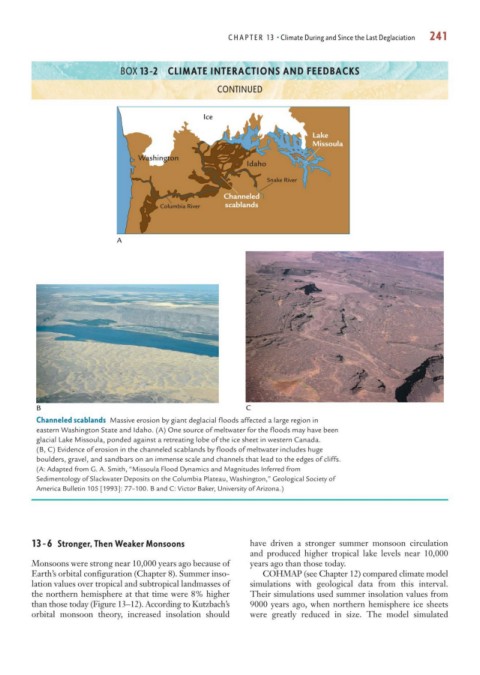
Channeled scablands Massive erosion by giant deglacial floods affected a large region in
eastern Washington State and Idaho. (A) One source of meltwater for the floods may have been
glacial Lake Missoula, ponded against a retreating lobe of the ice sheet in western Canada.
(B, C) Evidence of erosion in the channeled scablands by floods of meltwater includes huge
boulders, gravel, and sandbars on an immense scale and channels that lead to the edges of cliffs.
(A: Adapted from G. A. Smith, “Missoula Flood Dynamics and Magnitudes Inferred from
Sedimentology of Slackwater Deposits on the Columbia Plateau, Washington,” Geological Society of
America Bulletin 105 [1993]: 77–100. B and C: Victor Baker, University of Arizona.)
13-6 Stronger, Then Weaker Monsoons have driven a stronger summer monsoon circulation
and produced higher tropical lake levels near 10,000
Monsoons were strong near 10,000 years ago because of years ago than those today.
Earth’s orbital configuration (Chapter 8). Summer inso- COHMAP (see Chapter 12) compared climate model
lation values over tropical and subtropical landmasses of simulations with geological data from this interval.
the northern hemisphere at that time were 8% higher Their simulations used summer insolation values from
than those today (Figure 13–12). According to Kutzbach’s 9000 years ago, when northern hemisphere ice sheets
orbital monsoon theory, increased insolation should were greatly reduced in size. The model simulated