
Page 285 - Fundamentals of Geomorphology
P. 285
268 PROCESS AND FORM
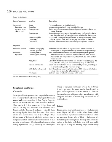
Table 10.4—Cont’d
Formative process Landform Description
Ice-contact Kame Flat-topped deposit of stratified debris
deposition from Kame field Large area covered with many individual kames
meltwater or in Kame plateau Broad area of ice-contact sediments deposited next to a glacier but
lakes or both not yet dissected
Kame terrace Kame deposited by a stream flowing between the flank of a glacier
and the valley wall, left stranded on the hillside after the ice goes
Kame delta (delta Flat-topped, fan-shaped mound formed by meltwater coming from a
moraine) glacier snout or flank and discharging into a lake or the sea
Crevasse fill Stratified debris carried into crevasses by supraglacial meltwater
Proglacial
Meltwater erosion Scabland topography, Meltwater features in front of a glacier snout. Water collected in
coulee, spillway ice-marginal or proglacial lakes may overflow through spillways
Meltwater Outwash plain or Plain formed of material derived wholly or partially from glacial
deposition sandur (plural sandar) debris transported or reworked by meltwater and other streams.
Most sandar are composed wholly of outwash, but some contain
inwash as well
Valley train Collection of coarse river-sediment and braided rivers occupying the
full width of a valley with mountains rising steep at either side
Braided outwash fan Debris fan formed where rivers, constrained by valleys, disembogue
on to lowlands beyond a mountain range
Kettle (kettle hole, pond) Bowl-shaped depression in glacial sediment left when a detached or
buried block of ice melts. Often contains a pond
Pitted plain Outwash plain pitted with numerous kettle holes
Source: Adapted from Hambrey (1994)
Subglacial landforms release of subglacial meltwater. Where the meltwater
is under pressure, the water may be forced uphill to
Channels give a reversed gradient, as in the Rinnen of Denmark.
Subglacial gorges, which are often several metres wide
Some glacial landscapes contain a range of channels cut compared with tens of metres deep, are carved out of
into bedrock and soft sediments. The largest of these are solid bedrock.
tunnel valleys, such as those in East Anglia, England,
which are eroded into chalk and associated bedrock.
They can be 2–4 km wide, over 100 m deep, and Eskers
30–100 km long, and sediments – usually some com-
bination of silt, clay, gravel, and peat – often fill them Eskers are the chief landform created by subglacial melt-
to varying depths. As to their formation, three mech- water (Figure 10.7; Plate 10.14). Minor forms include
anisms may explain these tunnels (Ó’Cofaigh 1996): sediment-filled Nye channels and moulin kames, which
(1) the creep of deformable subglacial sediment into a are somewhat fleeting piles of debris at the bottom of a
subglacial conduit, and the subsequent removal of this moulin (a pothole in a glacier that may extend from the
material by meltwater; (2) subglacial meltwater erosion surface to the glacier bed). Esker is an Irish word and is
during deglaciation; and (3) erosion by the catastrophic now applied to long and winding ridges formed mostly