
Page 105 - Fundamentals of Ocean Renewable Energy Generating Electricity From The Sea
P. 105
98 Fundamentals of Ocean Renewable Energy
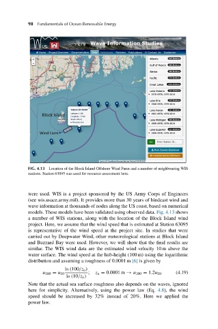
FIG. 4.13 Location of the Block Island Offshore Wind Farm and a number of neighbouring WIS
stations. Station 63095 was used for resource assessment here.
were used. WIS is a project sponsored by the US Army Corps of Engineers
(see wis.usace.army.mil). It provides more than 30 years of hindcast wind and
wave information at thousands of nodes along the US coast, based on numerical
models. These models have been validated using observed data. Fig. 4.13 shows
a number of WIS stations, along with the location of the Block Island wind
project. Here, we assume that the wind speed that is estimated at Station 63095
is representative of the wind speed at the project site. In studies that were
carried out by Deepwater Wind, other meteorological stations at Block Island
and Buzzard Bay were used. However, we will show that the final results are
similar. The WIS wind data are the estimated wind velocity 10 m above the
water surface. The wind speed at the hub-height (100 m) using the logarithmic
distribution and assuming a roughness of 0.0001 m [6] is given by
ln (100/z o )
u 100 = u 10 ; z o = 0.0001 m → u 100 = 1.2u 10 (4.19)
ln (10/z o )
Note that the actual sea surface roughness also depends on the waves, ignored
here for simplicity. Alternatively, using the power law (Eq. 4.8), the wind
speed should be increased by 32% instead of 20%. Here we applied the
power law.