
Page 232 - Geochemical Anomaly and Mineral Prospectivity Mapping in GIS
P. 232
234 Chapter 7
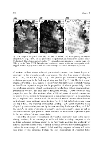
Fig. 7-20. Maps of integrated EBFs [(A) Unc, (B) Pls and (C) Dis] accompanying the map of
integrated Bel (Fig. 7-19A) for the proposition of epithermal Au prospectivity, Aroroy district
(Philippines). The inference network in Fig. 7-4 was used in combining input evidential maps with
EBFs given in Table 7-VIII. Triangles are locations of known epithermal Au deposits; whilst
polygon outlined in grey is area of stream sediment sample catchment basins (see Fig. 4-11).
of locations without stream sediment geochemical evidence, have lowest degrees of
uncertainty in the proposition under examination. The other final maps of integrated
EBFs – Unc, Dis and Pls (Fig. 7-20) – also provide geo-information regarding the
predictions portrayed in the final map of integrated Bel (Fig. 7-19A). The final map of
integrated Unc (Fig. 7-20A) depicts locations where the input pieces of spatial evidence
are insufficient to provide support for the proposition of mineral prospectivity. In the
case study area, examples of such locations are obviously those without stream sediment
geochemical evidence. The final map of integrated Pls (Fig. 7-20B) depicts not only
prospective areas but also locations where additional pieces of spatial evidence are
required to provide support for the proposition of mineral prospectivity. In the case study
area, examples of such locations are in the east-central parts of the area where there are
multi-element stream sediment anomalies (see Fig. 5-12) but faults/fractures are scarce
(see Fig. 5-13A). The final map of integrated Dis (Fig. 7-20C) complements the pieces
of spatial geo-information provided by the corresponding final maps of integrated Bel,
Unc and Pls in terms of depicting prospective and non-prospective areas as well as
locations where the input pieces of spatial evidence are insufficient to provide support
for the proposition of mineral prospectivity.
The ability of explicit representation of evidential uncertainty, even in the case of
missing evidence, is an advantage of evidential belief modeling compared to the
modeling techniques explained earlier. As in fuzzy logic modeling, the availability of
different operators and the ability to modify inference networks for combining pieces of
evidence is an advantage of evidential belief modeling compared to binary and multi-
class index overlay modeling. Perhaps the only disadvantage of evidential belief