
Page 234 - Geology of Carbonate Reservoirs
P. 234
DEPOSITIONAL RESERVOIRS 215
LAFAYETTE COLUMBIA MT HOLLY
VILLAGE
MAGNOLIA UNION
MCKANNE-PATTON
DORCHEAT-MACEDONIA
ATLANTA
SCHULER
LAKE ERLING B
C
NORTH HAYNESVILLE ARKANSAS
HAYNESVILLE
LICK CREEK LOUISIANA
CARTERVILLE RED ROCK
BOSSIER
HAYNESVILLE COLOUITY
WEBSTER
MT. SIHAI
AMTIOCH
LEGEND
Buckner-Haynesville Fault System
CLAIBORNE
Smackover Grainstone Trend
SCALE IN MILES
Buckner ls. Production
6 3 0 6 12
Smackover ls. Production
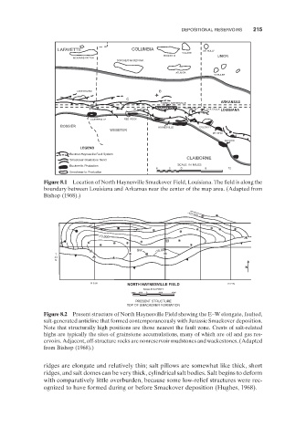
Figure 8.1 Location of North Haynesville Smackover Field, Louisiana. The field is along the
boundary between Louisiana and Arkansas near the center of the map area. (Adapted from
Bishop ( 1968 ).)
L -10,500
-10,000
S
SW -10,000
T
23
N
N
R 8 W NORTH HAYNESVILLE FIELD R 7 W
SCALE IN FEET
2000 1000 0 2000 4000
PRESENT STRUCTURE
TOP OF SMACKOVER FORMATION
Figure 8.2 Present structure of North Haynesville Field showing the E – W elongate, faulted,
salt - generated anticline that formed contemporaneously with Jurassic Smackover deposition.
Note that structurally high positions are those nearest the fault zone. Crests of salt - related
highs are typically the sites of grainstone accumulations, many of which are oil and gas res-
ervoirs. Adjacent, off - structure rocks are nonreservoir mudstones and wackestones. (Adapted
from Bishop ( 1968 ).)
ridges are elongate and relatively thin; salt pillows are somewhat like thick, short
ridges, and salt domes can be very thick, cylindrical salt bodies. Salt begins to deform
with comparatively little overburden, because some low - relief structures were rec-
ognized to have formed during or before Smackover deposition (Hughes, 1968 ).