
Page 236 - Geology of Carbonate Reservoirs
P. 236
DEPOSITIONAL RESERVOIRS 217
150’ 50’
T
23
N
N
R 8 W NORTH HAYNESVILLE FIELD R 7 W
SCALE IN FEET
2000 1000 0 2000 4000
SMACKOVER FACIES
Well-Developed Large Oolites
Mixed Oolites and Peloids
Peloids, Mud, Sparse Oolites
A Productive from Reservoir Facies
400’
350’
300’
250’
200’
150’
250’
100’
200’
150’
100’
50’
150’ 50’
T
23
N
N
R 8 W NORTH HAYNESVILLE FIELD R 7 W
SCALE IN FEET
2000 1000 0 2000 4000
B BUCKER FORMATION ISOPACH
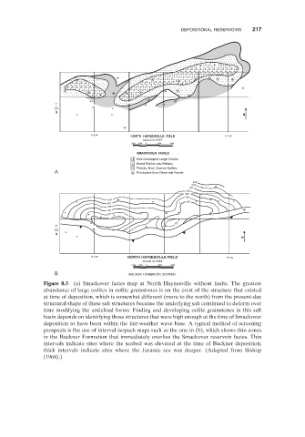
Figure 8.3 (a) Smackover facies map at North Haynesville without faults. The greatest
abundance of large oolites in oolite grainstones is on the crest of the structure that existed
at time of deposition, which is somewhat different (more to the north) from the present - day
structural shape of these salt structures because the underlying salt continued to deform over
time modifying the anticlinal forms. Finding and developing oolite grainstones in this salt
basin depends on identifying those structures that were high enough at the time of Smackover
deposition to have been within the fair - weather wave base. A typical method of screening
prospects is the use of interval isopach maps such as the one in (b), which shows thin zones
in the Buckner Formation that immediately overlies the Smackover reservoir facies. Thin
intervals indicate sites where the seabed was elevated at the time of Buckner deposition;
thick intervals indicate sites where the Jurassic sea was deeper. (Adapted from Bishop
( 1968 ).)