
Page 126 - Geothermal Energy Renewable Energy and The Environment
P. 126
112 Geothermal Energy: Renewable Energy and the Environment
an accurate means for discriminating between minerals that compose rocks and surface deposits.
However, combining spectral analysis at infrared and visible wavelengths provides sufficient dis-
criminatory capability to allow identification of surface minerals, particularly in regions where
evaporation has resulted in the concentration of highly soluble minerals that precipitate from waters
that have collected in closed basins. Significant in these studies is the ability to identify borate
minerals (Crowley 1993; Stearns, van der Horst, and Swihart 1999; Crowley, Mars, and Hook 2000;
Khalili and Safaei 2002; Kratt, Coolbaugh, and Calvin 2006; Coolbaugh 2007; Kratt et al. 2009).
As previously noted, boron is commonly elevated in geothermal waters. Evaporite deposits that
contain borate minerals may thus provide an indication of a previously active geothermal spring or
other water source that may not currently be active. In other words, detection of such deposits may
be a means for identifying hidden resources.
The electromagnetic spectrum covers wavelengths from about 10 microns (gamma rays) to more
−6
8
than 10 microns (TV and radio waves). The visible portion of the spectrum occupies the region from
about 0.4 microns (blue light) to about 0.7 microns (red light). Just beyond the longer wavelength
portion of the visible spectrum is the infrared portion of the spectrum. The infrared includes the
near infrared, at 0.7 to 1.2 microns, the solar reflected infrared at 1.2–3.2 microns, the mid-infrared
at 3.2–15 microns and the far infrared at > 15 microns. Laboratory measurements of the reflected
visible and infrared light from samples of pure minerals allow the characteristic reflectance spectra
of minerals to be determined and used as a standard against which field measurements can be com-
pared. Careful analysis and signal processing allows the identification of specific minerals in soils
and rocks composed of a mineral mixture.
Although field measurements of the reflectance spectra of soils and rocks can be made using
handheld instruments, the process requires large amounts of time to survey the many square kilo-
meters necessary to explore for evidence of hidden resources. Recently, airborne and satellite-borne
instruments on a variety of satellites have been employed to map mineral distributions in areas that
may contain geothermal resources that are not otherwise readily identified.
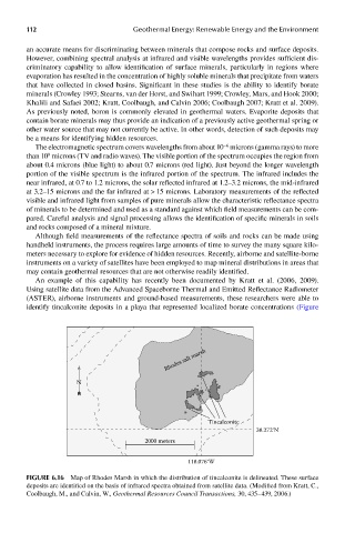
An example of this capability has recently been documented by Kratt et al. (2006, 2009).
Using satellite data from the Advanced Spaceborne Thermal and Emitted Reflectance Radiometer
(ASTER), airborne instruments and ground-based measurements, these researchers were able to
identify tincalconite deposits in a playa that represented localized borate concentrations (Figure
Rhodes salt marsh
N
Tincalconite
38.272°N
2000 meters
118.076°W
FIGUre 6.16 Map of Rhodes Marsh in which the distribution of tincalconite is delineated. These surface
deposits are identified on the basis of infrared spectra obtained from satellite data. (Modified from Kratt, C.,
Coolbaugh, M., and Calvin, W., Geothermal Resources Council Transactions, 30, 435–439, 2006.)