
Page 125 - Geothermal Energy Renewable Energy and The Environment
P. 125
Exploring for Geothermal Systems 111
CCP 1612 1650 1700 1750 1800 1850
0.200
Line 36
0.000
0.250
Base of the
Ligurid units
0.500
0.750
Top of the
metamorphic
basament
1.000
1.250
1.500
1.750 Geothermal
target
Line 16
Well
2.000
2.250
2.500 Line 36
2.750
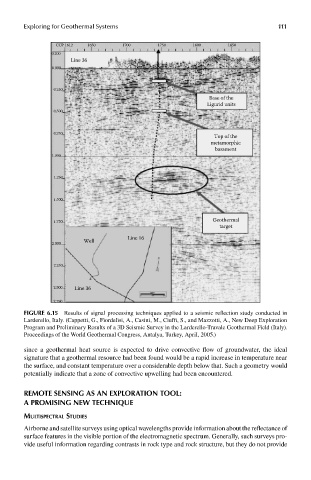
FIGUre 6.15 Results of signal processing techniques applied to a seismic reflection study conducted in
Larderello, Italy. (Cappetti, G., Fiordelisi, A., Casini, M., Ciuffi, S., and Mazzotti, A., New Deep Exploration
Program and Preliminary Results of a 3D Seismic Survey in the Larderello-Travale Geothermal Field (Italy).
Proceedings of the World Geothermal Congress, Antalya, Turkey, April, 2005.)
since a geothermal heat source is expected to drive convective flow of groundwater, the ideal
signature that a geothermal resource had been found would be a rapid increase in temperature near
the surface, and constant temperature over a considerable depth below that. Such a geometry would
potentially indicate that a zone of convective upwelling had been encountered.
remoTe sensInG as an exploraTIon Tool:
a promIsInG new TechnIqUe
mulTispecTral sTudies
Airborne and satellite surveys using optical wavelengths provide information about the reflectance of
surface features in the visible portion of the electromagnetic spectrum. Generally, such surveys pro-
vide useful information regarding contrasts in rock type and rock structure, but they do not provide