
Page 185 - Geothermal Energy Renewable Energy and The Environment
P. 185
Generating Power Using Geothermal Resources 171
(a) Volcanic rocks (b)
of the Cascade Mountains Clear lake
122° 45' W
N
zone
MTJ –2100 –1500 >–2100
Cascadia subduction
MFZ 40 N –900
–1500 –900
- 1500
Clear lake –300 –2100
–2100
San andreas volcanics –900 Clear lake 38° 45' N
fault
20 km volcanics
San francisco
300 km
125 W 120 W
(c)
38° 52' >–2100
–2100 –1500
–900
Cobb Mtn.
38° 48' - 1500
–1500
–900
–2100
–300 –2100
SEGEP pipeline –900
1.0 km
–1500
38° 44'
122° 52' 122° 48' 122° 44' 122° 40'
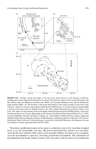
FIGUre 9.14 Geologic setting and depth to the top of the steam horizon at The Geysers, California.
(a). Regional tectonic framework showing the location of The Geysers relative to the Cascade Mountains, the
San Andreas fault, the Mendocino fracture zone (MFZ), the Cascadia subduction zone, and the Mendocino
triple junction (MTJ). (b). The location of the steam field relative to the surface location of the Clear Lake
Volcanics, which are volcanic rocks erupted within the last 700,000 years. (c). Contour map showing the depth
to the top of the steam reservoir (dashed contour is the –300 m depth). Elevations are in meters relative to sea
level. Also shown are the locations of the power plants (shaded hexagons) and the SEGEP pipeline. (Data from
Geothermal Resources Council, Monograph on The Geysers Geothermal Field, Special Report No. 17, 1992;
Lawrence Berkeley National Laboratory, Calpine, Inc., and Northern California Power Agency, Integrated
High Resolution Microearthquake Analysis and Monitoring for Optimizing Steam Production at The Geysers
Geothermal Field, California. California Energy Commission, Geothermal Resources Development Account
Final Report for Grant Agreement GEO-00-003, 2004.)
The primary geothermal resource in the region is a subsurface zone of dry steam that is trapped
below a very low permeability rock mass. The process that formed this system is not well under-
stood, but the basic elements of the system can be described. Shallow level heat sources commonly
cause the development of vigorously convecting groundwater environments. The combination of
hot groundwater and freshly erupted volcanic rocks can readily result in extensive recrystallization