
Page 117 - Global Tectonics
P. 117
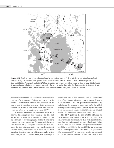
104   CHAPTER 5


                                             MR
                             Canada
                                            Alpha Ridge
                              Basin                     Lomonosov Ridge


                      120 W                                                       30 E
                                       AHI
                                                   130
                                            120
                                          EI
                                             110     80 N

                                     100
                       90 W                         Greenland                     0
                                            Baffin Bay  70  60
                                        90

                                    80      70             50
                                                                40
                                                     70 N            30  20
                                                                          10 0


                                                                          Iceland
                                        60 W                      30 W

           Figure 5.11  Predicted hotspot track assuming that the Iceland hotspot is fixed relative to the other Indo-Atlantic

           hotspots of Fig. 5.9. Position of hotspot at 10 Ma intervals is indicated by solid dots. AHI, Axel Heiberg Island; EI,
           Ellesmere Island; MR, Mendeleyev Ridge. Dashed line, continent–ocean boundary based on bathymetry. Gap between

           70 Ma positions results from sea floor created after the passage of the Labrador Sea Ridge over the hotspot at 70 Ma

           (modified and redrawn from Lawver & Müller, 1994, courtesy of the Geological Society of America).


           stationary in the mantle, and so their trajectories provide   is obtained. This is then compared with the track of the
           a record of the motions of plates with respect to the   axis of the hotspot reference frame as viewed from the

           mantle. A combination of these two methods can be   fixed continent. The TPW path is then determined by
           used to test if there has been any relative movement   calculating the angular rotation that shifts the global
           between the mantle and the Earth’s spin axis. This phe-  mean paleomagnetic pole of a certain age to the north
           nomenon is known as true polar wander (TPW).  pole, and then applying the same rotation to the hotspot
             The method employed to investigate TPW is as   pole of the same age (Courtillot & Besse, 1987).
           follows. Paleomagnetic pole positions for the past   The TPW path for the past 200 Ma, obtained by
           200 Ma are compiled for a number of continents that   Besse & Courtillot (2002), is shown in Fig. 5.12. Their
           are separated by spreading oceans so that their relative   analysis utilizes paleomagnetic data from six continents,

           motions can be reconstructed from magnetic lineation   sea floor spreading data from the Atlantic and Indian
           data (Section 4.1.7). The pole positions are then cor-  Oceans, and the Indo-Atlantic hotspot reference frame
           rected for the rotations relative to a single continent   of Müller et al. (1993) for the past 130 Ma, and of Morgan
           (usually Africa) experienced as a result of sea fl oor   (1983) for the period from 130 to 200 Ma. They conclude
           spreading since the time for which they apply. In this   that as much as 30° of true polar wander has occurred
           way a composite or global apparent polar wander path   in the past 200 Ma, and that the movement of the pole