
Page 167 - Global Tectonics
P. 167
CONTINENTAL RIFTS AND RIFTED MARGINS 153
7.1 INTRODUCTION failed rifts include the Mesozoic Connecticut Valley
in the northeastern United States and the North Sea
Basin.
Studies of active rifts show that their internal struc-
Continental rifts are regions of extensional deformation ture, history, and dimensions are highly variable
where the entire thickness of the lithosphere has (Ruppel, 1995). Much of this variability can be
deformed under the influence of deviatoric tension. explained by differences in the strength and rheology
The term “rift” thus applies only to major lithospheric of the lithosphere (Section 2.10) at the time rifting
features and does not encompass the smaller-scale initiates and by processes that influence these proper-
extensional structures that can form in association with ties as rifting progresses (Section 7.6.1). Where the
virtually any type of deformation. lithosphere is thick, cool, and strong, rifts tend to form
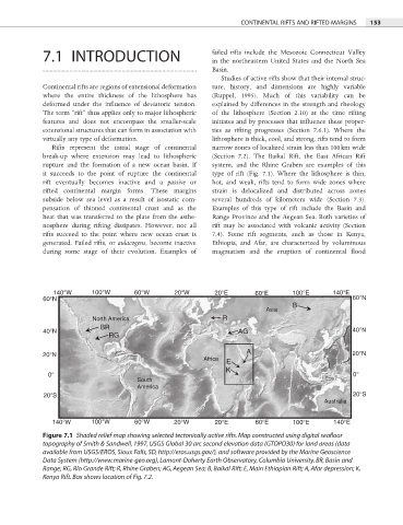
Rifts represent the initial stage of continental narrow zones of localized strain less than 100 km wide
break-up where extension may lead to lithospheric (Section 7.2). The Baikal Rift, the East African Rift
rupture and the formation of a new ocean basin. If system, and the Rhine Graben are examples of this
it succeeds to the point of rupture the continental type of rift (Fig. 7.1). Where the lithosphere is thin,
rift eventually becomes inactive and a passive or hot, and weak, rifts tend to form wide zones where
rifted continental margin forms. These margins strain is delocalized and distributed across zones
subside below sea level as a result of isostatic com- several hundreds of kilometers wide (Section 7.3).
pensation of thinned continental crust and as the Examples of this type of rift include the Basin and
heat that was transferred to the plate from the asthe- Range Province and the Aegean Sea. Both varieties of
nosphere during rifting dissipates. However, not all rift may be associated with volcanic activity (Section
rifts succeed to the point where new ocean crust is 7.4). Some rift segments, such as those in Kenya,
generated. Failed rifts, or aulacogens, become inactive Ethiopia, and Afar, are characterized by voluminous
during some stage of their evolution. Examples of magmatism and the eruption of continental fl ood
140°W 100°W 60°W 20°W 20°E 60°E 100°E 140°E
60°N 60°N
B
Asia
North America R
BR
40°N AG 40°N
RG
20°N A 20°N
Africa
E
K
0° 0°
South
America
20°S 20°S
Australia
140°W 100°W 60°W 20°W 20°E 60°E 100°E 140°E
Figure 7.1 Shaded relief map showing selected tectonically active rifts. Map constructed using digital seafloor
topography of Smith & Sandwell, 1997, USGS Global 30 arc second elevation data (GTOPO30) for land areas (data
available from USGS/EROS, Sioux Falls, SD, http://eros.usgs.gov/), and software provided by the Marine Geoscience
Data System (http://www.marine-geo.org), Lamont-Doherty Earth Observatory, Columbia University. BR, Basin and
Range; RG, Río Grande Rift; R, Rhine Graben; AG, Aegean Sea; B, Baikal Rift; E, Main Ethiopian Rift; A, Afar depression; K,
Kenya Rift. Box shows location of Fig. 7.2.