Page 168 - Global Tectonics
P. 168

154   CHAPTER 7


           (a)       20 E          30 E         40 E          50 E
              30 N                                                         30 N
                                              A R A B I A N   P L A T E
                      AFRICA                  ARABIAN PLATE
                      A F R I C A
              25 N                                                         25 N
                                                   16 mm a
                                                   16 mm a  1 1

                                                              30 mm a

                     NUBIAN PLATE
                     N U B I A N   P L A T E                  30 mm a  1 1
              20 N                               Red Sea                   20 N
                                                            23 mm a  1 1
                                                            23 mm a

                                                 Red Sea
                               10 mm a
                               10 mm a    1 1
              15 N                                                         15 N
                                                         Gulf of Aden
                                                         Gulf of Aden
                                                     Afar
                                               EP
                               6–7 mm a

              10 N             6–7 mm a  1 1   EP    Afar                  10 N
                       Turkana Depression
                       Turkana Depression       MER
                                                MER
               5 N                                 S O M A L I A N         5 N
                                                   SOMALIAN
                                            CB
                                            CB        PLATE
                                                      P L A T E
                                     A
                            Western
                            Western
                0                                                          0
                              Rift
                              Rift             Eastern
                                               Eastern
                                                 Rift
                                       EAP       Rift
                                       EAP
                                                       Indian
                                            M          Indian
                                                       Ocean
               5 S                                     Ocean               5 S
                                          K
                     20 E          30 E         40 E          50 E
            (b)  3         Karonga Basin L   120 km         (c)  3         Manyara Basin L   87 km
             km  0                                          km  0
                 3                      Livingstone fault       3
                                                                    Omo   Chew Bahir Basin L   65 km
            (d)  3              Albert Basin                (e)  3  Basin
             km  0                                          km  0
                 3       Bunia fault       Toro–Bunyoro fault   3
                                                                    Cenozoic volcanic rock
                                                                    Late Cenozoic sedimentary rock
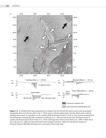
           Figure 7.2  (a) Shaded relief map and geodynamic setting of the East African Rift system constructed using digital
           topography data and software cited in Fig. 7.1. White arrows indicate relative plate velocities. Black arrows indicate
           absolute plate motion in a geodetic, no-net-rotation (NNR) framework (Section 5.4). (b–e) Cross-sections showing fault
           and half-graben morphology (after compilation of Ebinger et al., 1999, with permission from the Royal Society of
           London). M, Manyara basin (from Foster et al., 1997); K, Karonga basin (from van der Beek et al., 1998); A, Albert basin
           (from Upcott et al., 1996); CB, Chew Bahir basin (from Ebinger & Ibrahim, 1994); EAP, East African Plateau; EP,
           Ethiopian Plateau; MER, Main Ethiopian rift; L, the length of the border fault.
   163   164   165   166   167   168   169   170   171   172   173