
Page 170 - Global Tectonics
P. 170
156 CHAPTER 7
(a)
0 100 200 km
Tendaho Goba’ad
Kemise Discontinuity
BF
Nubian
plate Ataye
BF Afar Depression
Ankober Addo-do
10 N BF Mezezo Graben
Megezez Fantale-Dofan few data
Baso- MS
Werena A
basin Kereyou
Basin
Adama
Boset Basin
MS
Ziway-
Shalla N
Basin
A
8 N Somalian
plate
Border fault
Magmatic segment
40 E 42 E
Megezaz volcano Boset
closely spaced
(b) A ~10.5 Ma small-offset faults Keradi magmatic Arboye A
segment
fault
4 border fault
? ?
km 0 ? ?
4 VE is 2:1
0 50 100 150 km
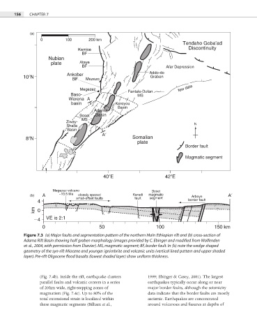
Figure 7.3 (a) Major faults and segmentation pattern of the northern Main Ethiopian rift and (b) cross-section of
Adama Rift Basin showing half graben morphology (images provided by C. Ebinger and modified from Wolfenden
et al., 2004, with permission from Elsevier). MS, magmatic segment; BF, border fault. In (b) note the wedge-shaped
geometry of the syn-rift Miocene and younger ignimbrite and volcanic units (vertical lined pattern and upper shaded
layer). Pre-rift Oligocene flood basalts (lowest shaded layer) show uniform thickness.
(Fig. 7.4b). Inside the rift, earthquake clusters 1999; Ebinger & Casey, 2001). The largest
parallel faults and volcanic centers in a series earthquakes typically occur along or near
of 20 km wide, right-stepping zones of major border faults, although the seismicity
magmatism (Fig. 7.4c). Up to 80% of the data indicate that the border faults are mostly
total extensional strain is localized within aseismic. Earthquakes are concentrated
these magmatic segments (Bilham et al., around volcanoes and fissures at depths of