
Page 241 - Global Tectonics
P. 241
CONTINENTAL TRANSFORMS AND STRIKE-SLIP FAULTS 227
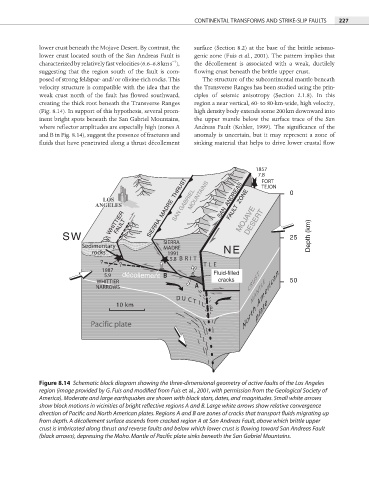
lower crust beneath the Mojave Desert. By contrast, the surface (Section 8.2) at the base of the brittle seismo-
lower crust located south of the San Andreas Fault is genic zone (Fuis et al., 2001). The pattern implies that
−1
characterized by relatively fast velocities (6.6–6.8 km s ), the décollement is associated with a weak, ductilely
suggesting that the region south of the fault is com- fl owing crust beneath the brittle upper crust.
posed of strong feldspar- and/or olivine-rich rocks. This The structure of the subcontinental mantle beneath
velocity structure is compatible with the idea that the the Transverse Ranges has been studied using the prin-
weak crust north of the fault has fl owed southward, ciples of seismic anisotropy (Section 2.1.8). In this
creating the thick root beneath the Transverse Ranges region a near vertical, 60- to 80-km-wide, high velocity,
(Fig. 8.14). In support of this hypothesis, several prom- high density body extends some 200 km downward into
inent bright spots beneath the San Gabriel Mountains, the upper mantle below the surface trace of the San
where reflector amplitudes are especially high (zones A Andreas Fault (Kohler, 1999). The significance of the
and B in Fig. 8.14), suggest the presence of fractures and anomaly is uncertain, but it may represent a zone of
fluids that have penetrated along a thrust décollement sinking material that helps to drive lower crustal fl ow
1857
7.8
FORT
TEJON
SAN GABRIEL
LOS SAN ANDREAS 0
ANGELES SIERRA MADRE THRUST MOUNTAINS FAULT ZONE
WHITTIER FAULT MOJAVE DESERT
SW 25 Depth (km)
SIERRA
Sedimentary MADRE NE
rocks 1991
? ? 5.8 BRIT
TLE
1987 Fluid-filled
5.9 décollement B
WHITTIER cracks CRUST 50
NARROWS A MANTLE
D U C T North American
10 km I L
E plate
Pacific plate
Figure 8.14 Schematic block diagram showing the three-dimensional geometry of active faults of the Los Angeles
region (image provided by G. Fuis and modified from Fuis et al., 2001, with permission from the Geological Society of
America). Moderate and large earthquakes are shown with black stars, dates, and magnitudes. Small white arrows
show block motions in vicinities of bright reflective regions A and B. Large white arrows show relative convergence
direction of Pacific and North American plates. Regions A and B are zones of cracks that transport fluids migrating up
from depth. A décollement surface ascends from cracked region A at San Andreas Fault, above which brittle upper
crust is imbricated along thrust and reverse faults and below which lower crust is flowing toward San Andreas Fault
(black arrows), depressing the Moho. Mantle of Pacific plate sinks beneath the San Gabriel Mountains.