
Page 21 - Hydrogeology Principles and Practice
P. 21
HYDC01 12/5/05 5:44 PM Page 4
4 Chapter One
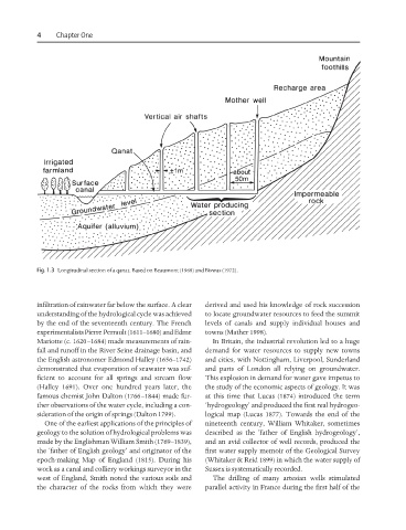
Fig. 1.3 Longitudinal section of a qanat. Based on Beaumont (1968) and Biswas (1972).
infiltration of rainwater far below the surface. A clear derived and used his knowledge of rock succession
understanding of the hydrological cycle was achieved to locate groundwater resources to feed the summit
by the end of the seventeenth century. The French levels of canals and supply individual houses and
experimentalists Pierre Perrault (1611–1680) and Edme towns (Mather 1998).
Mariotte (c. 1620–1684) made measurements of rain- In Britain, the industrial revolution led to a huge
fall and runoff in the River Seine drainage basin, and demand for water resources to supply new towns
the English astronomer Edmond Halley (1656–1742) and cities, with Nottingham, Liverpool, Sunderland
demonstrated that evaporation of seawater was suf- and parts of London all relying on groundwater.
ficient to account for all springs and stream flow This explosion in demand for water gave impetus to
(Halley 1691). Over one hundred years later, the the study of the economic aspects of geology. It was
famous chemist John Dalton (1766–1844) made fur- at this time that Lucas (1874) introduced the term
ther observations of the water cycle, including a con- ‘hydrogeology’ and produced the first real hydrogeo-
sideration of the origin of springs (Dalton 1799). logical map (Lucas 1877). Towards the end of the
One of the earliest applications of the principles of nineteenth century, William Whitaker, sometimes
geology to the solution of hydrological problems was described as the ‘father of English hydrogeology’,
made by the Englishman William Smith (1769–1839), and an avid collector of well records, produced the
the ‘father of English geology’ and originator of the first water supply memoir of the Geological Survey
epoch-making Map of England (1815). During his (Whitaker & Reid 1899) in which the water supply of
work as a canal and colliery workings surveyor in the Sussex is systematically recorded.
west of England, Smith noted the various soils and The drilling of many artesian wells stimulated
the character of the rocks from which they were parallel activity in France during the first half of the